kategoria
podkategoria
2018
-
Tercjak M., A. Gebauer, M. Rajner, A. Brzeziński i K. U. Schreiber. „On the phenomena disturbing the terrestrial orientation of the Wettzell g-Ring gyroscope”. , egu General Assembly 2018, , Geophysical Research Abstracts, 20:EGU2018–15069-1. Wiedeń, Austria.
- [bib]
@conference{2018TercjakEGU,
}author = {Tercjak, Monika and Gebauer, André and Rajner, Marcin and Brzeziński, Aleksander and Schreiber, Karl Ulrich}, title = {On the phenomena disturbing the terrestrial orientation of the Wettzell g-Ring gyroscope}, year = {2018}, month = {apr}, venue = {Austria Center Vienna, Hall X3}, date = {2018-04-10}, booktitle = {Geophysical Research Abstracts}, volume = {20}, pages = {EGU2018-15069-1}, eventtitle = {egu General Assembly 2018}, address = {Wiedeń, Austria}, presenter = {Monika Tercjak}, - [streszczenie]
Ring Laser Gyroscopes (RLGs) are instruments for measuring absolute rotation. They observe the so-called Sagnac effect, i.e. a phase shift of two light beams propagating in opposite directions around a circuit of a rotating gyro- scope. Although the two beams travel the same path in the same conditions, due to the sensor rotation they traverse different distances in itertial space. It results in the phase shift which is directly proportional to the dot product of the normal of the gyroscope and the vector of its rotation. Considering a large laser gyroscope firmly tied to the ground, it is quite obvious that the observed Sagnac effect is due to both Earth rotation perturbations and changes in the terrestrial orientation of the normal vector. We have already dealt with the first effect (M. Tercjak and A. Brzeziński (2017), Pure Appl. Geophys, Vol. 174 pp 2719–2731) and now we want to focus on the phenomena disturbing the terrestrial orientation of an instrument. According to (K.U. Schreiber and J. P. Wells (2013), Review of Scientific Instruments 84), the aforementioned phenomena are pressure loading around the sensor site, wind loads, ground water variations, microseismic activity, solid Earth tides and, especially for instruments located near to the seashore, ocean tidal loading. However, some effects are not easily modeled and therefore it is difficult to predict their impact. Within this work we make an overview of the effects affecting direction of the normal vector of the gyroscope g-Ring at the Wettzell Observatory, compare their impact and discuss a possibility of model- ing them. We compare different models of non-tidal loading effects (including our own modeling efforts), discuss two ways of modeling the impact of the solid Earth tides and verify required accuracy of the Love numbers used in computations. Moreover, we discuss the impact of the local atmospheric conditions on the observations and a possibility of reducing their impact.
- [bib]
2016
-
Chwedorzewska K. J., H. Galera, S. Łapiński, M. E. Kowalska, M. Pasik, M. Rajner, E. Czyż, P. Bylina, A. Znój i M. Wódkiewicz. „First step to eradication of Poa annua L. from Arctowski Oasis (King George Island, South Shetlands, Antarctica)”. , scar 2016 Open Science Conference, . Kuala Lumpur, Malezja, isbn 978-0-948277-32-0.
- [bib]
@conference{Chwedorzewska16,
}eventtitle = {scar 2016 Open Science Conference}, eventdate = {2016-08-20/2016-08-30}, year = {2016}, address = {Kuala Lumpur, Malezja}, author = {Chwedorzewska, Katarzyna J. and Galera, Halina and Łapiński, Sławomir and Kowalska, Maria Elżbieta and Pasik, Mariusz and Rajner, Marcin and Czyż, Ewa and Bylina, Paweł and Znój, Anna and Wódkiewicz, Maciej}, title = {First step to eradication of Poa annua L. from Arctowski Oasis (King George Island, South Shetlands, Antarctica)}, isbn = {978-0-948277-32-0}, month = {aug}, presenter = {Katarzyna Chwedorzewska}, - [streszczenie]
Poa annua is the only flowering plant species that has established a breeding population in the maritime Antarctic, through repeated anthropogenic introduction. Annual bluegrass inhabits mainly anthropogenic sites, but recently has entered tundra communities. The functioning of P. annua in the Antarctic could not have been possible without adaptations that enable the plants to persist in the specific climatic conditions typical for this zone. Poa annua is highly adaptable to environmental stress and unstable habitats: huge phenotypic and genotypic variability, small size, plastic life cycle (life-history types ranging from annual to perennial forms). The spreading of P. annua in the Antarctic Peninsula region is a classic example of the expansion process following anthropogenic introduction of an invasive species, and illustrates the dangers to Antarctic terrestrial ecosystems that are associated with increasing human traffic. We report the first steps to eradicate the species after all the necessary initial research has been conducted. After detailed mapping a part of the ―Arctowski‖ population closest to a valuable moss carpet formation has been removed. We removed altogether 314 out of 1439 tussocks growing in the vicinity of Station buildings and all of the 49 tussocks growing in the forefield of Ecology Glacier. In subsequent years we will continue the eradication process and monitor the eradicated sites. This will provide valuable information on procedures concerning removal of alien species in the maritime Antarctic and will help making future informed decisions for other invasions in the region.
- [.pdf]
- [bib]
-
Bakuła K., M. E. Kowalska, S. Łapiński, M. Pasik i M. Rajner. „Geodezyjne prace pomiarowo-badawcze w okolicy Polskiej Stacji Antarktycznej im. Henryka Arctowskiego podczas xxxix Polskiej Wyprawy Antarktycznej”. , xxxvi Sympozjum Polarne, (Progress in polar research — new experiences and challenges). Lublin.
- [bib]
@conference{SympozjumPolarne2016_prace_geodezyjne,
}year = {2016}, date = {2016-06-09}, month = {jun}, title = {Geodezyjne prace pomiarowo-badawcze w okolicy Polskiej Stacji Antarktycznej im. Henryka Arctowskiego podczas xxxix Polskiej Wyprawy Antarktycznej}, author = {Bakuła, Krzysztof and Kowalska, Maria Elżbieta and Łapiński, Sławomir and Pasik, Mariusz and Rajner, Marcin}, eventtitle = {xxxvi Sympozjum Polarne}, eventdate = {2016-06-08/2016-06-11}, eventtitleaddon = {Progress in polar research — new experiences and challenges}, venue = {Wydział Nauk o Ziemi i Gospodarki Przestrzennej umcs}, address = {Lublin}, - [streszczenie]
W opracowaniu zaprezentowano geodezyjne prace pomiarowo-badawcze, wykonane przez pracowników Wydziału Geodezji i Kartografii Politechniki Warszawskiej, w okolicy Polskiej Stacji Antarktycznej im. Henryka Arctowskiego, w trakcie xxxix Polskiej Wyprawy Antarktycznej na Wyspę Króla Jerzego w marcu 2015 r. Prace te miały na celu wykonanie dokumentacji geodezyjnej dla gospodarza stacji - Instytutu Biochemii i Biofizyki pan, niezbędnej do przygotowania projektu przebudowy lub budowy nowej stacji. W oparciu o przeprowadzone pomiary geodezyjne, wykonane za pomocą klasycznej tachimetrii oraz techniki gnss rtk, sporządzono mapę zasadniczą w skali 1:500 dla obszaru stacji i jej okolic. Dodatkowo wykonano inwentaryzację 3D obiektów stacji i jej bezpośredniego otoczenia z wykorzystaniem naziemnego skaningu laserowego. W oparciu o klasyczne dane i rezultaty skaningu opracowano wysokorozdzielcze numeryczne modele terenu stacji i jej sąsiedztwa. Są to pierwsze tak szczegółowe i dokładne opracowania, których treścią jest Polska Stacja. Praca przedstawia także precyzyjną osnowę geodezyjną założoną w okolicy stacji, której od powstania stacji do tej pory nie było. Ponadto, bazując na archiwalnych materiałach kartograficznych, przeprowadzono analizę zmian linii brzegowej, pod kątem oceny zagrożenia dla obiektów na terenie stacji.
- [bib]
-
Kowalska M. E., S. Łapiński, M. Pasik i M. Rajner. „Mapa zasadnicza Polskiej Stacji Antarktycznej im. Henryka Arctowskiego (Wyspa Króla Jerzego, Szetlandy Południowe)”. , xxxvi Sympozjum Polarne, (Progress in polar research — new experiences and challenges). Lublin.
- [bib]
@conference{SympozjumPolarne2016_mapa,
}year = {2016}, date = {2016-06-09}, month = {jun}, title = {Mapa zasadnicza Polskiej Stacji Antarktycznej im. Henryka Arctowskiego (Wyspa Króla Jerzego, Szetlandy Południowe)}, author = {Kowalska, Maria Elżbieta and Łapiński, Sławomir and Pasik, Mariusz and Rajner, Marcin}, eventtitle = {xxxvi Sympozjum Polarne}, venue = {Wydział Nauk o Ziemi i Gospodarki Przestrzennej umcs}, eventdate = {2016-06-08/2016-06-11}, address = {Lublin}, eventtitleaddon = {Progress in polar research — new experiences and challenges}, - [streszczenie]
Mapę zasadniczą Polskiej Stacji Antarktycznej im. Henryka Arctowskiego w skali 1:500 opracowano na podstawie danych pomiarowych zgromadzonych przez autorów w czasie wyprawy pomiarowo-badawczej na Wyspę Króla Jerzego w marcu 2015 r. Do pomiaru ponad 9 tys. punktów pomiarowych obejmujących obszar ok. 24 ha, zastosowano tachimetrię elektroniczną oraz technikę gnss rtk. Jako układ odniesienia zastosowano ITRF2008 (International Terrestrial Reference Frame) na epokę 2015.2, natomiast wysokości odniesiono do średniego poziomu morza w zatoce Admiralicji zaobserwowanego w latach 1998-1999. Opracowanie wykonano w systemie GEO-MAP w dwóch odwzorowaniach: Gaussa-Krügera z południkiem osiowym L o = 58o30’ W oraz utm (Universal Transverse Mercator) z południkiem osiowym L o = 57o W. Mapę w odwzorowaniu Gaussa-Krügera opracowaną w wersji polskojęzycznej, obejmującą teren stacji i jego sąsiedztwo, przekazano do dyspozycji Instytutu Biochemii i Biofizyki PAN oraz wykorzystano dla celów projektowych, związanych z przebudową stacji. Opracowanie w odwzorowaniu utm w wersji polskojęzycznej, obejmujące wyłącznie teren stacji, udostępniono na stronie stacji (http://www.arctowski.pl/arctowski/biblioteka/antar_mapki/arctowski_500.pdf). Mapę w tym samym odwzorowaniu w wersji anglojęzycznej umieszczono w międzynarodowym repozytorium opracowań kartograficznych scar Map Catalogue prowadzonym przez Australian Antarctic Data Centre. Jest ona dostępna do pobrania pod adresem http://data.aad.gov.au/aadc/mapcat/display_map.cfm?map_id=14496. Ze względu na symbolikę obiektów mapy zasadniczej, inną niż występująca na mapach topograficznych, udostępnione opracowania w odwzorowaniu utm opatrzono legendą.
- [bib]
2015
-
Rajner M. „Use of numerical weather models for atmospheric gravity corrections in terrestrial gravity measurements”. , 26th General Assembly of the International Union of Geodesy and Geophysics, (Earth and Environmental Sciences for Future Generations). Praga, Czechy.
- [bib]
@conference{Rajner2015_iugg,
}author = {Rajner, Marcin}, title = {Use of numerical weather models for atmospheric gravity corrections in terrestrial gravity measurements}, eventdate = {2015-06-22/2015-07-02}, date = {2015-06-30}, month = {jun}, year = {2015}, venue = {Praskie Centrum Konferencyjne, 5. kvetna 65 140 00 Praga 4}, address = {Praga, Czechy}, eventtitle = {26th General Assembly of the International Union of Geodesy and Geophysics}, eventtitleaddon = {Earth and Environmental Sciences for Future Generations}, - [streszczenie]
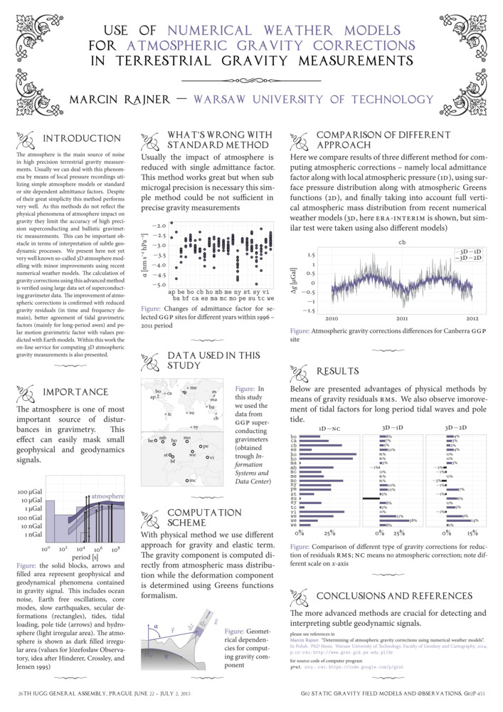
The atmosphere is the main source of noise in high precision terrestrial gravity measurements. Usually we can deal with this phenomena by means of local pressure recordings utilizing simple atmosphere models or standard or site dependent admittance factors. Despite of their great simplicity this method performs very well. As this methods do not reflect the physical phenomena of atmosphere impact on gravity they limit the accuracy of high precision superconducting and ballistic gravimetric measurements. This can be important obstacle in terms of interpretation of subtle geodynamic processes. We present here not yet very well known so-called 3D atmosphere modelling with minor improvements using recent numerical weather models. The calculation of gravity corrections using this advanced method is verified using large data set of superconducting gravimeter data. The improvement of atmospheric corrections is confirmed with reduced gravity residuals (in time and frequency domain), better agreement of tidal gravimetric factors (mainly for long-period awes) and polar motion gravimetric factor with values predicted with Earth models. Within this work the on-line service for computing 3D atmospheric gravity measurements is also presented.
- [.pdf]
- [url]
- [bib]
2013
-
Rajner M. „grat — open source software for computing atmospheric gravity correction using numerical weather models”. , iag Scientific Assembly, (iag 150 years). Poczdam, Niemcy.
- [bib]
@conference{Rajner2013_iag,
}date = {2013-09-01}, month = {sep}, year = {2013}, author = {Rajner, Marcin}, title = {grat — open source software for computing atmospheric gravity correction using numerical weather models}, eventtitle = {iag Scientific Assembly}, eventtitleaddon = {iag 150 years}, eventdate = {2013-09-01/2013-09-06}, venue = {Dorint Hotel}, address = {Poczdam, Niemcy}, note = {poster wyróżniony}, - [streszczenie]
In order to fully utilize the accuracy of modern ballistic and superconducting gravimeters we have to be able to remove all sources of disturbances in the measurements. One of the main effect is impact of atmosphere masses on surface gravity values. Usually we take this into account using pressure measurements along with single admittance factor. If the continuous gravity measurements at the site are at our disposal we can determine this factor by means of statistical methods. These methods perform very well and major part of atmospheric disturbances can be removed. Nevertheless these methods do not reflect the physical phenomena and are not adequate when accuracy of a few microGal is needed. This can be extremely important when one uses gravity measurements for tectonic studies. In this paper I introduce a new computer program (called grat) to facilitate computation of atmospheric gravity correction making extensive use of numerical weather models. Using meteorological parameters we can perform computation using 2D method (surface pressure with exponential pressure changes with height) and 3D method (numerical integration for vertical layers). We can compute separate the deformation as well as attraction terms using different Earth models and numerical weather models. We can also add the temperature, topography and Inverted Barometer effect. All possible combinations make this flexible and versatile tool. In opposition to existing services (atmacs and loading.u-strasbg.fr) we are not restricted for specific sites and we can perform computation according to our needs with use of plethora of switches. All sources of program (fully written in Fortran90 with elements of Fortran2003) are freely available. The usefulness of this program will be presented with comparison to other methods and services and with comparison with real data from absolute and relative gravimeters.
- [.pdf]
- [url]
- [bib]
-
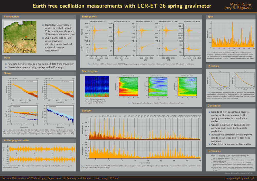
Rajner M. „Still valuable measurements taken with spring gravimeter — results from Józefosław observatory”. , 17th International Symposium on Earth Tides, (Understand the Earth). Warszawa.
- [bib]
@conference{Rajner13ets,
}title = {Still valuable measurements taken with spring gravimeter — results from Józefosław observatory}, author = {Rajner, Marcin}, eventtitle = {17th International Symposium on Earth Tides}, eventtitleaddon = {Understand the Earth}, eventdate = {2013-04-15/2013-04-19}, date = {2013-04-15}, month = {apr}, year = {2013}, venue = {cgs wat}, address = {Warszawa}, - [streszczenie]
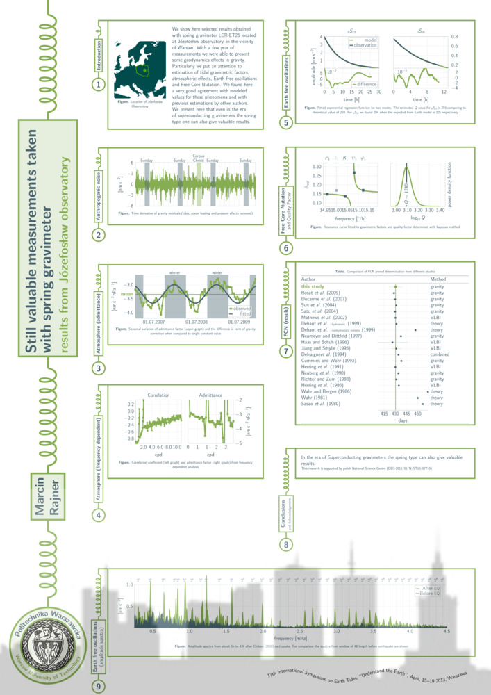
We show here selected results obtained with spring gravimeter lcr-et26 located at Józefosław observatory, in the vicinity of Warsaw. With a few year of measurements we were able to present some geodynamics effects in gravity. Particularly we put an attention to estimation of tidal gravimetric factors, ocean tidal loading, atmospheric effects, Earth free oscillations and Free Core Nutation. We found here a very good agreement with modeled values for these phenomena and with previous estimations by other authors. We present here that even in the era of superconducting gravimeters the spring type one can also give valuable results.
- [.pdf]
- [url]
- [bib]

2012
-
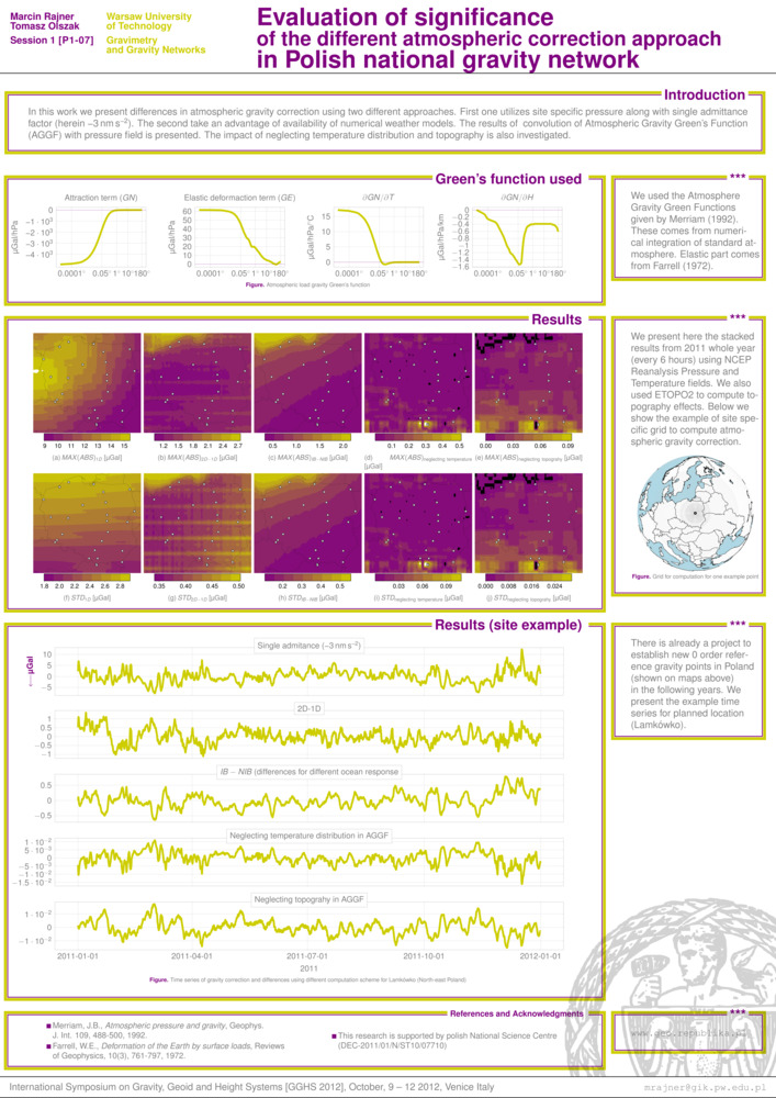
Rajner M. i T. Olszak. „Evaluation of significance of the different atmospheric correction approach in Polish national gravity network”. , International Symposium on Gravity, Geoid and Height Systems, . Wenecja, Włochy.
- [bib]
@conference{Rajner2012wenecja,
}author = {Rajner, Marcin and Olszak, Tomasz}, year = {2012}, title = {Evaluation of significance of the different atmospheric correction approach in Polish national gravity network}, eventtitle = {International Symposium on Gravity, Geoid and Height Systems}, eventdate = {2012-10-09/2012-10-12}, date = {2012-10-09}, month = {oct}, venue = {San Servolo}, address = {Wenecja, Włochy}, - [.pdf]
- [bib]
-
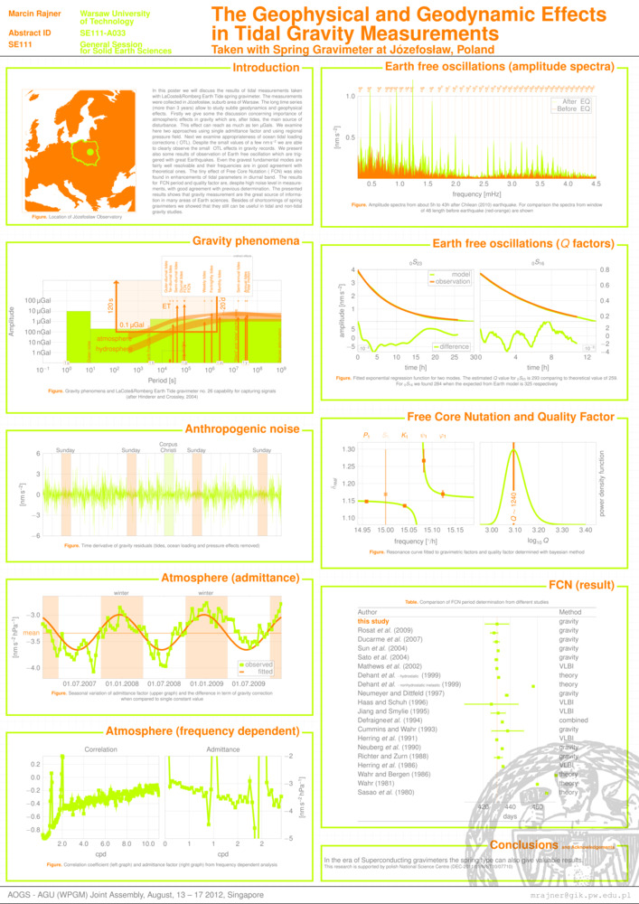
Rajner M. „The geophysical and geodynamic effects in tidal gravity measurements taken with spring gravimeter at Józefosław, Poland”. , aogs–agu (wpgm) Joint Assembly, . Singapur.
- [bib]
@conference{Rajnersingapur2012,
}author = {Rajner, Marcin}, year = {2012}, title = {The geophysical and geodynamic effects in tidal gravity measurements taken with spring gravimeter at Józefosław, Poland}, eventtitle = {aogs–agu (wpgm) Joint Assembly}, address = {Singapur}, eventdate = {2012-08-13/2012-08-17}, date = {2012-08-15}, month = {aug}, venue = {World Resort Sentosa}, - [.pdf]
- [bib]
-
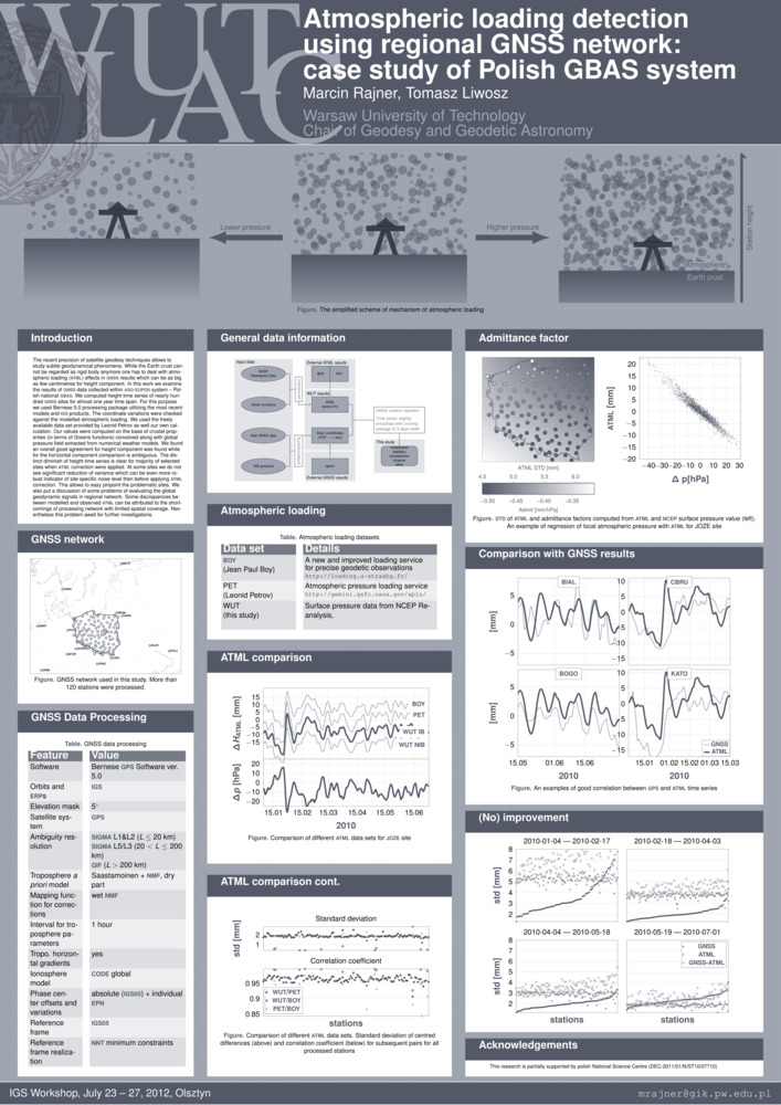
Rajner M. i T. Liwosz. „Atmospheric loading detection using regional gnss network: case study of Polish gbas system”. , igs Workshop, . Olsztyn.
- [bib]
@conference{RajnerLiwoszIGS2012,
}author = {Rajner, Marcin and Liwosz, Tomasz}, year = {2012}, title = {Atmospheric loading detection using regional gnss network: case study of Polish gbas system}, eventtitle = {igs Workshop}, eventdate = {2012-07-23/2012-07-27}, month = {jul}, address = {Olsztyn}, venue = {uwm}, - [.pdf]
- [bib]
-
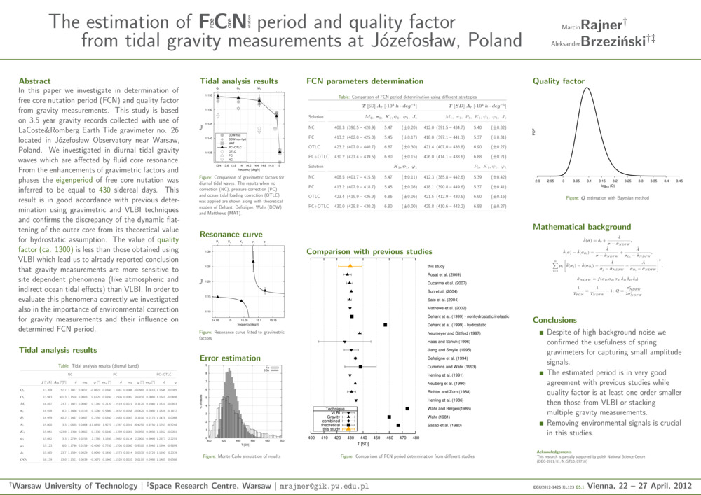
Rajner M. i A. Brzeziński. „The estimation of Free Core Nutation period and quality factor from tidal gravity measurements at Józefosław, Poland”. , egu General Assembly, , egu General Assembly Conference Abstracts, redaktor A. Abbasi i N. Giesen, 14:14253. Wiedeń, Austria.
- [bib]
@conference{RajnerBrzezinskiegu2012,
}author = {Rajner, Marcin and Brzeziński, Aleksander}, title = {The estimation of Free Core Nutation period and quality factor from tidal gravity measurements at Józefosław, Poland}, year = {2012}, month = {apr}, eventtitle = {egu General Assembly}, address = {Wiedeń, Austria}, eventdate = {2012-04-22/2012-04-27}, presenter = {Marcin Rajner}, booktitle = {egu General Assembly Conference Abstracts}, series = {egu General Assembly Conference Abstracts}, volume = {14}, editor = {Abbasi, A. and Giesen, N.}, pages = {14253}, - [.pdf]
- [bib]
-
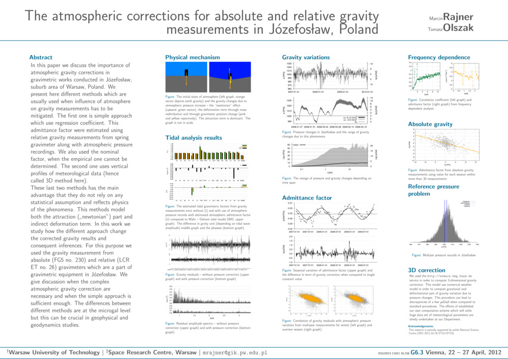
Rajner M. i T. Olszak. „The atmospheric corrections for absolute and relative gravity measurements in Józefosław, Poland”. , egu General Assembly, , egu General Assembly Conference Abstracts, redaktor A. Abbasi i N. Giesen, 14:11651. Wiedeń, Austria.
- [bib]
@conference{RajnerOlszakegu2012,
}author = {Rajner, Marcin and Olszak, Tomasz}, title = {The atmospheric corrections for absolute and relative gravity measurements in Józefosław, Poland}, eventtitle = {egu General Assembly}, address = {Wiedeń, Austria}, eventdate = {2012-04-22/2012-04-27}, booktitle = {egu General Assembly Conference Abstracts}, year = {2012}, month = {apr}, volume = {14}, editor = {Abbasi, A. and Giesen, N.}, pages = {11651}, - [.pdf]
- [bib]
2011
-
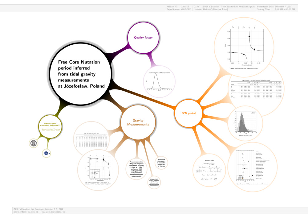
Rajner M. i A. Brzeziński. „Free Core Nutation period inferred from tidal gravity measurements at Józefosław, Poland”. , agu Fall Meeting, , agu Fall Meeting Abstracts. San Francisco, ca, usa.
- [bib]
@conference{RajnerBrzezinskiAGU11,
}author = {Rajner, Marcin and Brzeziński, Aleksander}, year = {2011}, title = {Free Core Nutation period inferred from tidal gravity measurements at Józefosław, Poland}, eventtitle = {agu Fall Meeting}, venue = {Moscon Centre}, address = {San Francisco, ca, usa}, eventdate = {2011-12-05/2011-12-09}, month = {dec}, booktitle = {agu Fall Meeting Abstracts}, - [.pdf]
- [bib]
-
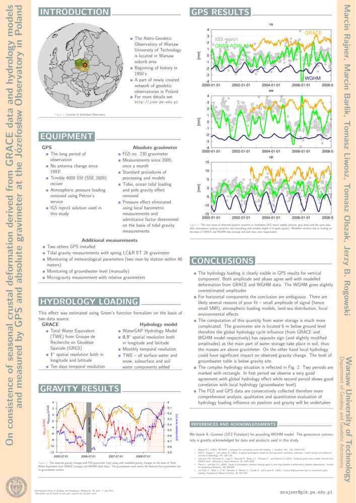
Rajner M., M. Barlik, T. Liwosz, T. Olszak i J. B. Rogowski. „On consistence of seasonal crustal deformation derived from grace data and hydrology models and measured by gps and absolute gravimeter at the Józefosław observatory in Poland”. , iugg, . Melbourne, Australia.
- [bib]
@conference{RajnerIUGG11,
}author = {Rajner, Marcin and Barlik, Marcin and Liwosz, Tomasz and Olszak, Tomasz and Rogowski, Jerzy B.}, year = {2011}, title = {On consistence of seasonal crustal deformation derived from grace data and hydrology models and measured by gps and absolute gravimeter at the Józefosław observatory in Poland}, eventtitle = {iugg}, address = {Melbourne, Australia}, eventdate = {2011-06-28/2011-07-07}, month = {jul}, presenter = {Tomasz Liwosz}, - [.pdf]
- [bib]
-
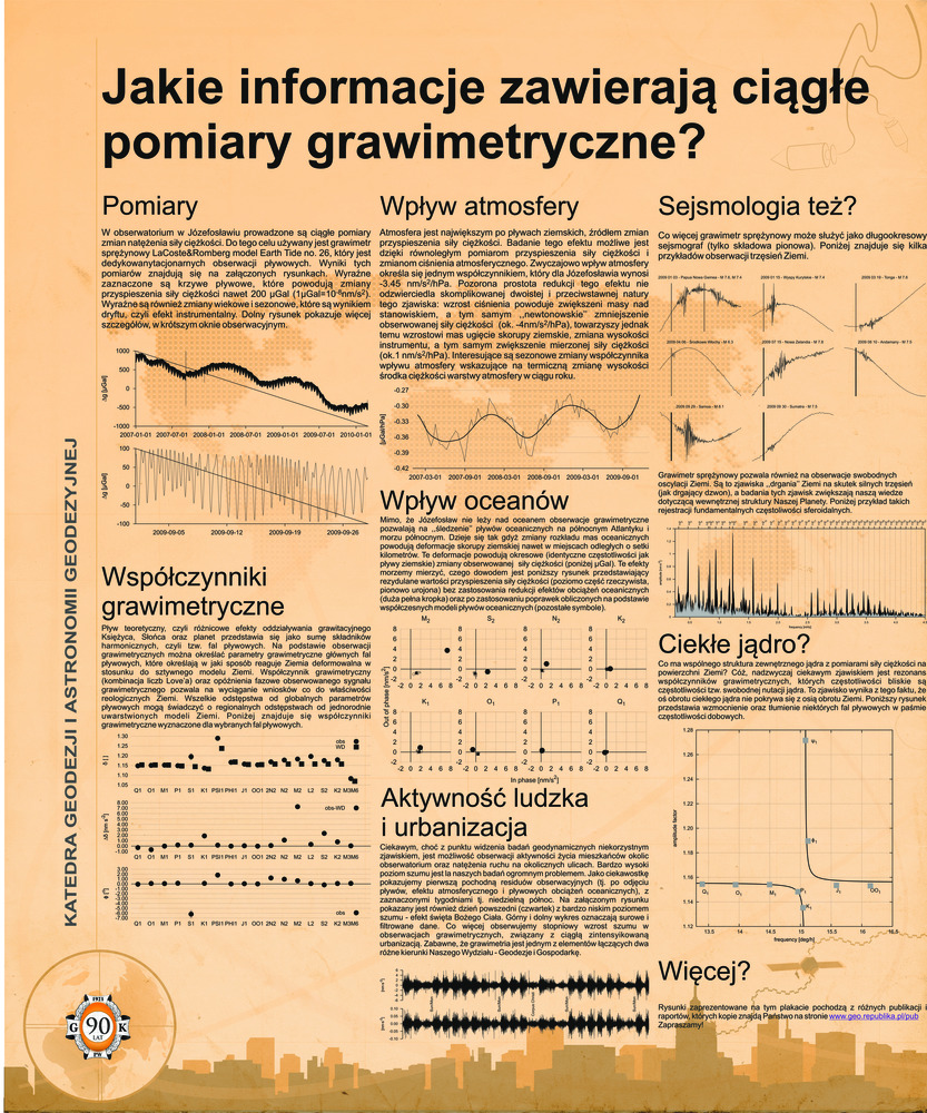
Rajner M. „Jakie informacje zawierają ciągłe pomiary grawimetryczne?” , 90-lecie Wydziału gik, . Warszawa.
- [bib]
@conference{Rajner90latGiK,
}author = {Rajner, Marcin}, year = {2011}, title = {Jakie informacje zawierają ciągłe pomiary grawimetryczne?}, eventtitle = {90-lecie Wydziału gik}, address = {Warszawa}, eventdate = {2011-05-27}, date = {2011-05-27}, month = {may}, - [.pdf]
- [bib]
-
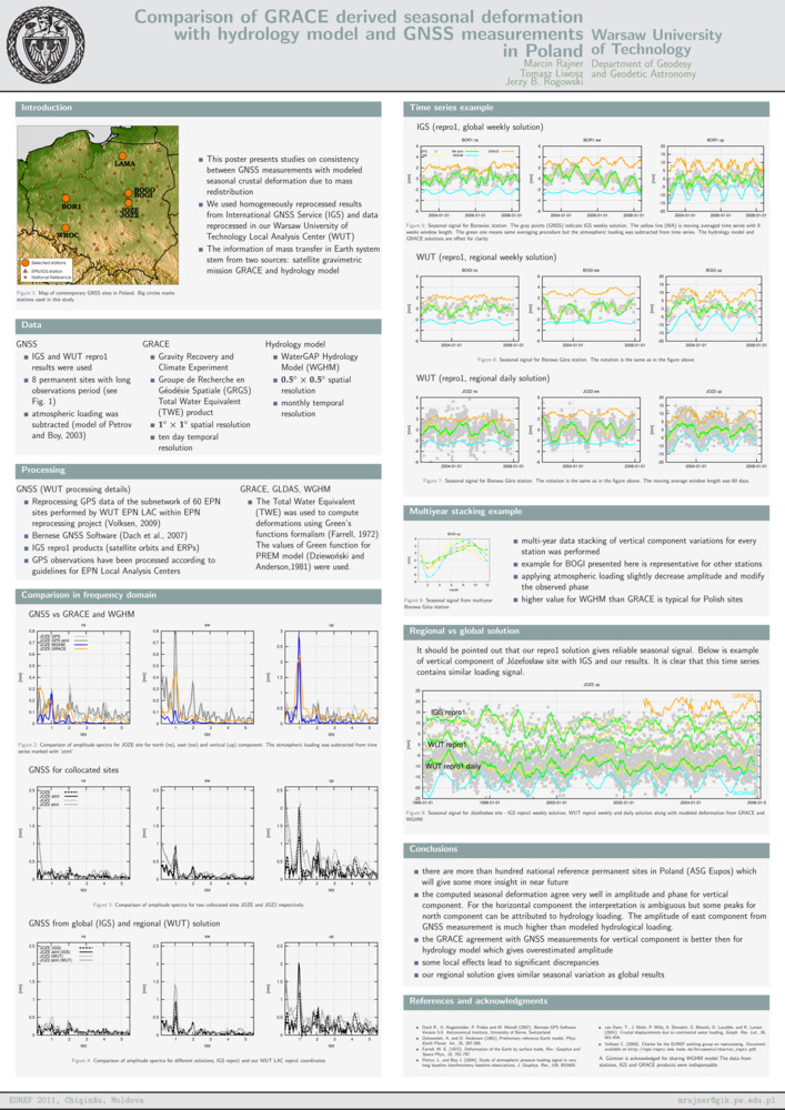
Rajner M., T. Liwosz i J. B. Rogowski. „Comparison of grace derived seasonal deformation with hydrology model and gnss measurements in Poland”. , euref Symposium, . Kiszyniów, Mołdawia.
- [bib]
@conference{Rajneretalpostereuref11,
}author = {Rajner, Marcin and Liwosz, Tomasz and Rogowski, Jerzy B.}, year = {2011}, eventtitle = {euref Symposium}, address = {Kiszyniów, Mołdawia}, eventdate = {2011-05-25/2011-05-28}, date = {2011-05-26}, month = {may}, venue = {Codru Hotel}, title = {Comparison of grace derived seasonal deformation with hydrology model and gnss measurements in Poland}, - [.pdf]
- [bib]
-
Rajner M. i J. B. Rogowski. „Earth free oscillation measurements with lcr-et26 spring gravimeter”. , egu General Assembly, . Wiedeń, Austria.
- [bib]
@conference{RajnerRogowski11,
}author = {Rajner, Marcin and Rogowski, Jerzy B.}, title = {Earth free oscillation measurements with lcr-et26 spring gravimeter}, year = {2011}, eventtitle = {egu General Assembly}, address = {Wiedeń, Austria}, eventdate = {2011-04-03/2011-04-08}, month = {apr}, - [.pdf]
- [bib]
-
Liwosz T. i M. Rajner. „Detection of site displacements caused by the 2010 flood in Poland”. , egu General Assembly, . Wiedeń, Austria.
- [bib]
@conference{LiwoszRajner11,
}author = {Liwosz, Tomasz and Rajner, Marcin}, title = {Detection of site displacements caused by the 2010 flood in Poland}, eventtitle = {egu General Assembly}, address = {Wiedeń, Austria}, eventdate = {2011-04-03/2011-04-08}, year = {2011}, month = {apr},
- [bib]
2010
-
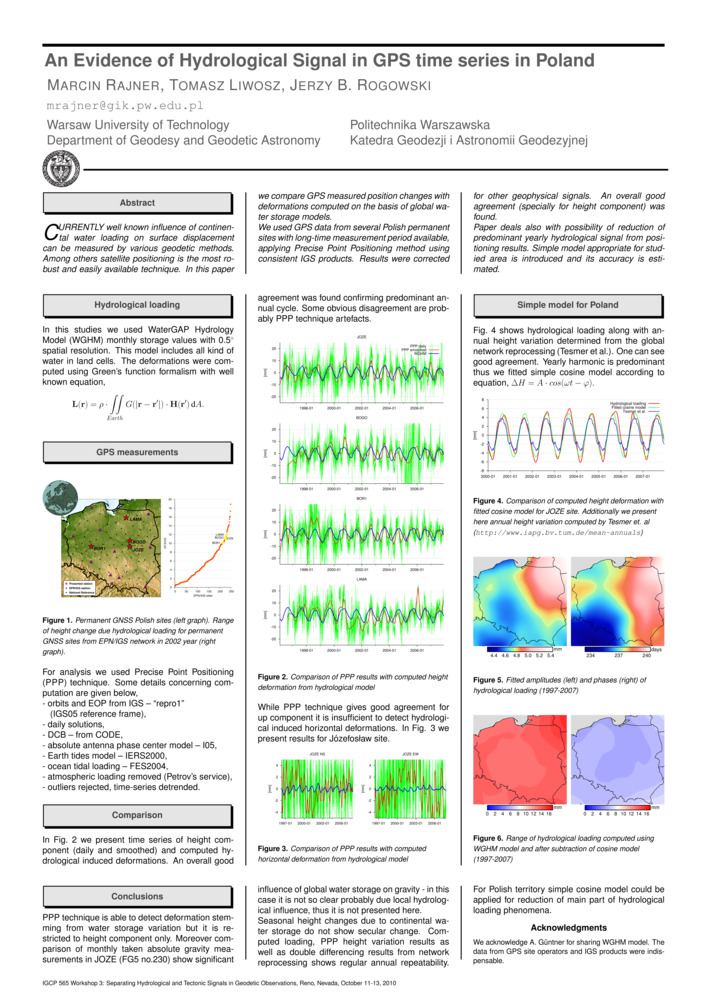
Rajner M., T. Liwosz i J. B. Rogowski. „An Evidence of Hydrological Signal in gps time series in Poland”. , igcp 565 Workshop 3: Separating Hydrological and Tectonic Signals in Geodetic Observations, . Reno, nv, usa.
- [bib]
@conference{Rajneretalreno10,
}author = {Rajner, Marcin and Liwosz, Tomasz and Rogowski, Jerzy B.}, year = {2010}, title = {An Evidence of Hydrological Signal in gps time series in Poland}, eventtitle = {igcp 565 Workshop 3: Separating Hydrological and Tectonic Signals in Geodetic Observations}, eventdate = {2010-10-11/2010-10-13}, month = {oct}, address = {Reno, nv, usa}, presenter = {Marcin Rajner}, - [.pdf]
- [bib]
-
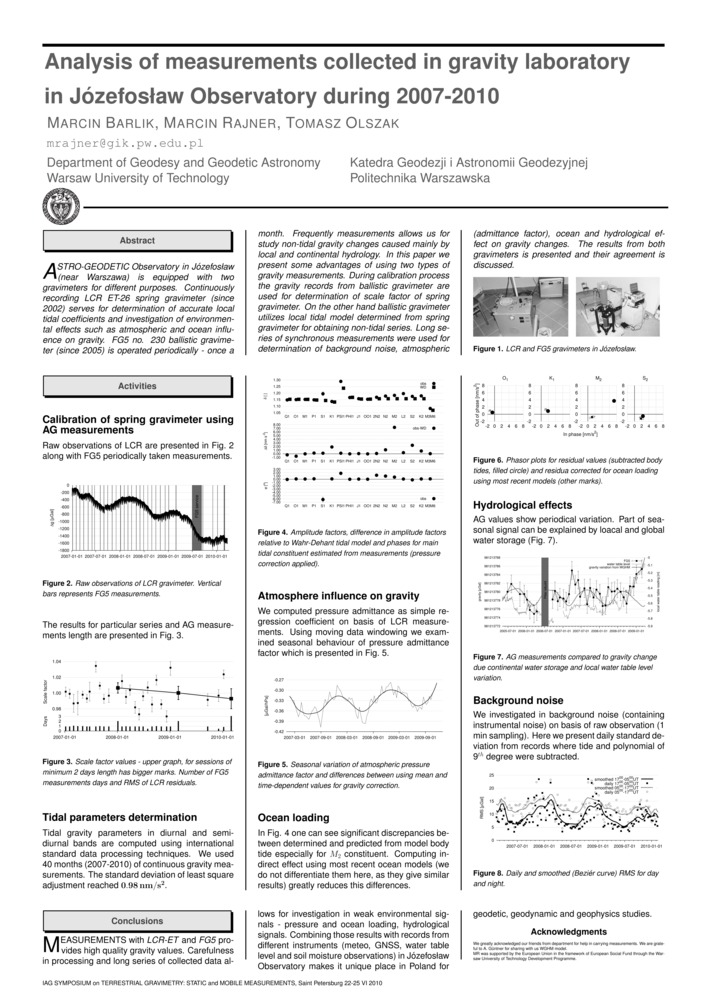
Barlik M., M. Rajner i T. Olszak. „Analysis of measurements collected in gravity laboratory in Józefosław Observatory during 2007-2010”. , International Association of Geodesy Symposium on Terrestial Gravimetry: Static and Mobile Measurements (tg-smm2010), . Sankt Petersburg, Rosja.
- [bib]
@conference{Barlik10c,
}author = {Barlik, Marcin and Rajner, Marcin and Olszak, Tomasz}, title = {Analysis of measurements collected in gravity laboratory in Józefosław Observatory during 2007-2010}, year = {2010}, eventtitle = {International Association of Geodesy Symposium on Terrestial Gravimetry: Static and Mobile Measurements (tg-smm2010)}, address = {Sankt Petersburg, Rosja}, eventdate = {2010-06-22/2010-06-25}, presenter = {Marcin Rajner}, month = {jun}, - [.pdf]
- [bib]
-
Barlik M., T. Olszak, A. Pachuta, D. Próchniewicz i M. Rajner. „Activities of the gravimetric laboratory at Józefosław observatory”. , egu General Assembly, , egu General Assembly Conference Abstracts, 12:7138. Wiedeń, Austria.
- [bib]
@conference{Barlik10a,
}author = {Barlik, Marcin and Olszak, Tomasz and Pachuta, Andrzej and Próchniewicz, Dominik and Rajner, Marcin}, title = {Activities of the gravimetric laboratory at Józefosław observatory}, year = {2010}, eventtitle = {egu General Assembly}, address = {Wiedeń, Austria}, eventdate = {2010-05-02/2010-05-07}, booktitle = {egu General Assembly Conference Abstracts}, series = {egu General Assembly Conference Abstracts}, volume = {12}, month = {may}, pages = {7138},
- [bib]
-
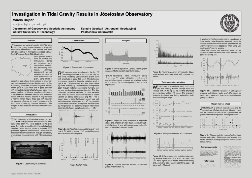
Rajner M. „Investigation in Tidal Gravity Results in Józefosław observatory”. , egu General Assembly, , egu General Assembly Conference Abstracts, 12:5925. Wiedeń, Austria.
- [bib]
@conference{Rajner10b,
}author = {Rajner, Marcin}, title = {Investigation in Tidal Gravity Results in Józefosław observatory}, year = {2010}, eventtitle = {egu General Assembly}, address = {Wiedeń, Austria}, eventdate = {2010-05-02/2010-05-07}, booktitle = {egu General Assembly Conference Abstracts}, series = {egu General Assembly Conference Abstracts}, volume = {12}, month = {may}, pages = {5925}, - [.pdf]
- [bib]
-
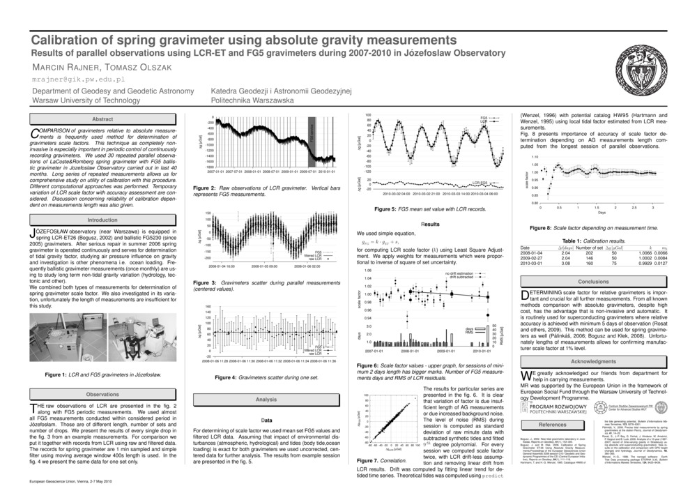
Rajner M. i T. Olszak. „Calibration of spring gravimeter using absolute gravity measurements. Results of parallel observations using lcr-et and fg5 gravimeters during 2007-2010 in Józefosław Observatory”. , egu General Assembly, , egu General Assembly Conference Abstracts, 12:5919. Wiedeń, Austria.
- [bib]
@conference{Rajner10a,
}author = {Rajner, Marcin and Olszak, Tomasz}, title = {Calibration of spring gravimeter using absolute gravity measurements. Results of parallel observations using lcr-et and fg5 gravimeters during 2007-2010 in Józefosław Observatory}, year = {2010}, eventtitle = {egu General Assembly}, address = {Wiedeń, Austria}, eventdate = {2010-05-02/2010-05-07}, booktitle = {egu General Assembly Conference Abstracts}, series = {egu General Assembly Conference Abstracts}, volume = {12}, month = {may}, pages = {5919}, - [.pdf]
- [bib]
2008
-
Walo J., K. Węzka, Z. Malinowski, M. Rajner, A. Adamek, A. Pachuta i D. Próchniewicz. „Monitoring of thickness and movements of the Hans glacier surface in a period of 2005-2006 by using gps-rtk technology”. , International Geodetic Student Meeting, . Walencja, Hiszpania.
- [bib]
@conference{Walo08,
}author = {Walo, Janusz and Węzka, Kinga and Malinowski, Zbigniew and Rajner, Marcin and Adamek, Artur and Pachuta, Andrzej and Próchniewicz, Dominik}, title = {Monitoring of thickness and movements of the Hans glacier surface in a period of 2005-2006 by using gps-rtk technology}, eventtitle = {International Geodetic Student Meeting}, address = {Walencja, Hiszpania}, month = {may}, year = {2008},
- [bib]
2007
-
Węzka K., A. Pachuta, M. Rajner, D. Próchniewicz, J. Walo i A. Adamek. „Monitoring of thickness and movements of the Hans glacier surface in a period of 2005-2006 by using gps-rtk technology”. , egu General Assembly, , Geophysical Research Abstracts, 9:11039. Wiedeń, Austria.
- [bib]
@conference{Wezka07,
}author = {Węzka, Kinga and Pachuta, Andrzej and Rajner, Marcin and Próchniewicz, Dominik and Walo, Janusz and Adamek, Artur}, title = {Monitoring of thickness and movements of the Hans glacier surface in a period of 2005-2006 by using gps-rtk technology}, year = {2007}, eventtitle = {egu General Assembly}, address = {Wiedeń, Austria}, booktitle = {Geophysical Research Abstracts}, volume = {9}, pages = {11039}, - [streszczenie]
The aim of the expedition organised in the summer 2006 by the Faculty of Geodesy and Cartography of the Warsaw University of Technology was the determination of thickness and motion of the selected part of the Hans glacier. Based on the surveys data from the last year the lateral profile has been staked out and set up near the 4th ablation pole. gps-rtk surveys were undertaken on the profile in three epochs. The technology has provided the determination of the glacier motion by the most useful and economic method. The paper presents the analysis of the measurements.
- [.pdf]
- [bib]
-
Pachuta A., J. Walo, M. Woźniak, A. Adamek, K. Węzka, D. Próchniewicz i M. Rajner. „Prace geodezyjne realizowane podczas wypraw arktycznych pracowników i studentów Wydziału Geodezji i Kartografii Politechniki Warszawskiej”. , Problemy w Geodezji Inżynieryjno-Przemysłowej, . Warszawa.
- [bib]
@conference{Pachuta07b,
}author = {Pachuta, Andrzej and Walo, Janusz and Woźniak, Marek and Adamek, Artur and Węzka, Kinga and Próchniewicz, Dominik and Rajner, Marcin}, title = {Prace geodezyjne realizowane podczas wypraw arktycznych pracowników i studentów Wydziału Geodezji i Kartografii Politechniki Warszawskiej}, eventtitle = {Problemy w Geodezji Inżynieryjno-Przemysłowej}, address = {Warszawa}, year = {2007},
- [bib]
2006
-
Walo J., K. Węzka, A. Adamek, M. Rajner, Z. Malinowski i A. Pachuta. „Polish Geodetic Students Expeditions to the Horsund Fjord in Spitsbergen”. , Shaping the Change, xxiii fig Congress, . Monachium, Niemcy.
- [bib]
@conference{Wezka06a,
}author = {Walo, Janusz and Węzka, Kinga and Adamek, Artur and Rajner, Marcin and Malinowski, Zbigniew and Pachuta, Andrzej}, title = {Polish Geodetic Students Expeditions to the Horsund Fjord in Spitsbergen}, year = {2006}, eventtitle = {Shaping the Change, xxiii fig Congress}, address = {Monachium, Niemcy}, eventdate = {2006-10-08/2006-10-13}, presenter = {Węzka, Kinga}, month = {oct}, - [.pdf]
- [bib]
-
Walo J., A. Pachuta, A. Adamek, K. Węzka, M. Rajner i Z. Malinowski. „Using gps reference station near Polish Polar Station in Spitsbergen for environment monitoring and geodynamic purposes”. , egu General Assembly, . Wiedeń, Austria.
- [bib]
@conference{Walo06nie07,
}author = {Walo, Janusz and Pachuta, Andrzej and Adamek, Artur and Węzka, Kinga and Rajner, Marcin and Malinowski, Zbigniew}, title = {Using gps reference station near Polish Polar Station in Spitsbergen for environment monitoring and geodynamic purposes}, year = {2006}, eventtitle = {egu General Assembly}, address = {Wiedeń, Austria},
- [bib]
-
Walo J., D. Puczko, A. Adamek, K. Węzka, M. Rajner i Z. Malinowski. „Monitoring of Hans Glacier movement dynamics (Hornsund sw Spitsbergen, Svalbard)”. , egu General Assembly, . Wiedeń, Austria.
- [bib]
@conference{Walo06b,
}author = {Walo, Janusz and Puczko, Dariusz and Adamek, Artur and Węzka, Kinga and Rajner, Marcin and Malinowski, Zbigniew}, title = {Monitoring of Hans Glacier movement dynamics (Hornsund sw Spitsbergen, Svalbard)}, eventtitle = {egu General Assembly}, address = {Wiedeń, Austria}, year = {2006}, - [streszczenie]
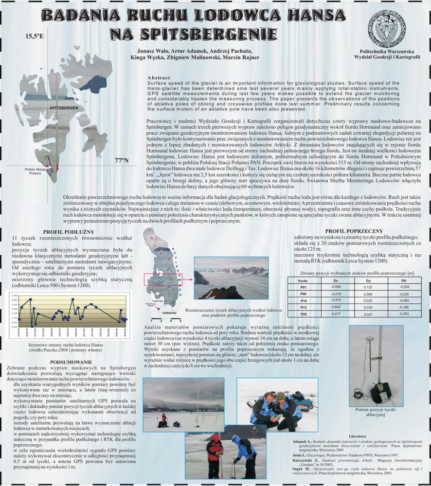
Surface speed of the glacier is an important information for glaciological studies. Surface speed of the Hans-glacier has been determined sine last several years mainly applying total-station instruments. GPS satellite measurements during last few years make possible to extend the glacier monitoring and considerably hasten the measuring process. The paper presents the observations done last summer of the positions of ablative poles oblong and crosswise profiles. The results concerning the surface motion of an ablative pole are presented in the paper.
- [.pdf]
- [bib]
2005
-
Walo J., A. Adamek, A. Pachuta, K. Węzka, Z. Malinowski i M. Rajner. „Badania ruchu lodowca Hansa na Spitsbergenie”. , Geodetické siete a priestorové informácie, . Podbanské, Słowacja.
- [bib]
@conference{Walo05b,
}author = {Walo, Janusz and Adamek, Artur and Pachuta, Andrzej and Węzka, Kinga and Malinowski, Zbigniew and Rajner, Marcin}, title = {Badania ruchu lodowca Hansa na Spitsbergenie}, eventtitle = {Geodetické siete a priestorové informácie}, eventdate = {2005-10-24/2005-10-26}, address = {Podbanské, Słowacja}, month = {oct}, year = {2005}, - [streszczenie]
Określenie powierzchniowej prędkości lodowca to ważna informacja dla badań glacjologicznych. Powierzchniowy ruch lodowca Hansa wyznaczany jest od kilku lat głównie za pomocą tachimetru elektronicznego. Wykorzystanie w ostatnich dwóch latach w obserwacji satelitarnych GPS pozwoliło rozszerzyć zasięg monitorowania lodowca i znacznie przyspieszyć prace pomiarowe. W referacie omówione zostały pomiary pozycji tyczek profili podłu nego i poprzecznego wykonane latem tego roku. Prezentowane są te wstępne wyniki dotyczące ruchu powierzchniowego dla wybranej tyczki ablacyjnej.
Surface speed of the glacier is an important information for glaciological studies. Surface speed of the Hans-glacier has been determined sine last several years mainly applying total-station instruments. GPS satellite measurements during last few years makes possible to extend the glacier monitoring and considerably hasten the measuring process. The paper presents the observations of the positions of ablative poles of oblong and crosswise profiles done last summer. Preliminary results concerning the surface motion of an ablative pole have been also presented. - [.pdf]
- [bib]