kategoria
podkategoria
2021
-
. Dzień Teledetekcji \’2021.
- [bib]
@conference{2021_Pasik_dzien_tele,
}eventtitle = {Dzień Teledetekcji \’2021}, venue = {MS Teams}, date = {2021-12-21}, year = {2021},
- [bib]
2020
-
Rajner M. „Dynamika lodowców na Svalbardzie badana z pomocą obserwacji GNSS”. Seminarium Zakładu Geodezji Planetarnej cbk i Katedry Geodezji i Astronomii Geodezyjnej pw.
- [bib]
@seminar{Rajner2020cbk,
}author = {Rajner, Marcin}, year = {2020}, title = {Dynamika lodowców na Svalbardzie badana z pomocą obserwacji GNSS}, eventtitle = {Seminarium Zakładu Geodezji Planetarnej cbk i Katedry Geodezji i Astronomii Geodezyjnej pw}, venue = {webex}, address = {zdalnie}, date = {2020-10-23}, month = {oct}, presenter = {Marcin Rajner}, - [.pdf]
- [bib]
2019
-
Olszak T., M. Rajner i V. Szabó. „Activities of gravimetric laboratory of Warsaw University of Technology at Józefosław (Poland)”. 27th iugg General Assembly.
- [bib]
@conference{2019Olszakiuggjoze,
}author = {Olszak, Tomasz and Rajner, Marcin and Szabó, Viktor}, title = {Activities of gravimetric laboratory of Warsaw University of Technology at Józefosław (Poland)}, year = {2019}, month = {jul}, date = {2019-07-13}, eventdate = {2019-07-08/2019-07-18}, eventtitle = {27th iugg General Assembly}, presenter = {Viktor Szabó}, - [.pdf]
- [bib]
-
Scherneck H.-G., M. Rajner i M. Mouyen. „Superconducting and Absolute Gravimetry: Reprocessing of the multi-campaign adjustment 2009-2017 — and obstacles for adding 2018”. nkg wggeo and wgfhsg meeting.
- [bib]
@conference{2019_Lyngby_Scherneck,
}title = {Superconducting and Absolute Gravimetry: Reprocessing of the multi-campaign adjustment 2009-2017 — and obstacles for adding 2018}, author = {Scherneck, Hans-Georg and Rajner, Marcin and Mouyen, Maxime}, eventtitle = {nkg wggeo and wgfhsg meeting}, eventdate = {2019-03-11/2019-03-13}, presenter = {Hans-Georg Scherneck}, year = {2019}, month = {mar},
- [bib]
-
Mouyen M., H.-G. Scherneck i M. Rajner. „Investigation of hydrological effects at the superconducting gravimetry site of Onsala”. nkg wggeo and wgfhsg meeting.
- [bib]
@conference{2019_Lyngby_Mouyen,
}title = {Investigation of hydrological effects at the superconducting gravimetry site of Onsala}, author = {Mouyen, Maxime and Scherneck, Hans-Georg and Rajner, Marcin}, presenter = {Maxime Mouyen}, eventtitle = {nkg wggeo and wgfhsg meeting}, eventdate = {2019-03-11/2019-03-13}, year = {2019}, month = {mar},
- [bib]
2018
-
Haas R., S. Casey, G. Elgered, R. Hammargren, L. Helldner, K.-Å. Johansson, U. Kylenfall, M. Lerner, L. Pettersson, M. Pantaleev, L. Wennerbäck i M. Rajner. „Status of the Onsala twin telescopes”. nkg 2018 (Geodesy in a Dynamic World — Celebrating 100 year anniversary of fgi).
- [bib]
@conference{2018_Haas_ott_nkg,
}title = {Status of the Onsala twin telescopes}, author = {Haas, Rüdiger and Casey, Simon and Elgered, Gunnar and Hammargren, Roger and Helldner, Leif and Johansson, Karl-Åke and Kylenfall, Ulf and Lerner, Mikael and Pettersson, Lars and Pantaleev, Miroslav and Wennerbäck, Lars and Rajner, Marcin}, eventtitle = {nkg 2018}, eventtitleaddon = {Geodesy in a Dynamic World — Celebrating 100 year anniversary of fgi}, venue = {Pasilan virastokeskus}, presenter = {Marcin Rajner}, eventdate = {2018-09-03/2018-09-06}, date = {2018-09-06}, year = {2018}, month = {sep},
- [bib]
-
Scherneck H.-G. i M. Rajner. „Contributions to the Analysis of Absolute Gravity Campaigns at Onsala 2009-2017”. nkg 2018 (Geodesy in a Dynamic World — Celebrating 100 year anniversary of fgi).
- [bib]
@conference{2018_Scherneck_nkg,
}title = {Contributions to the Analysis of Absolute Gravity Campaigns at Onsala 2009-2017}, author = {Scherneck, Hans-Georg and Rajner, Marcin}, eventtitle = {nkg 2018}, eventtitleaddon = {Geodesy in a Dynamic World — Celebrating 100 year anniversary of fgi}, venue = {Pasilan virastokeskus}, presenter = {Marcin Rajner}, eventdate = {2018-09-03/2018-09-06}, date = {2018-09-05}, year = {2018}, month = {sep}, - [streszczenie]
We report on efforts to provide reduction data for AG campaigns using the SG GWR054. Instead of g-software reduction for tides etc., the basic idea is to subtract low-pass filtered SG data (even at the the exact drop times, eventually supplemented with accelerations from a broadband seismometer). Thus, AG data could be reduced for a wider range of secular effects in gravity variation; and we alleviate limitations of the representation of tides and loading effects in g-software. The AG-SG reduction comprises all campaigns (with FG-220(X) from IfE Hannover and FG-233(X) from Lantmäteriet) from 2009 to 2017 in a single adjustment, aiming at the determination of . The crucial point here is to accurately determine the drift of the SG. A range of solutions from tide analysis employs different strategies that affect in particular the long-period domain. The station is located near the coast of the semi-enclosed basin of Kattegat, which urges us to carefully separate long-term effects from atmosphere and sea level. Finally we report on the determination of the SG scale factor and the time delay in the SG’s signal chain. The scale factor can be determined in each AG campaign separately, and a long-term value can be obtained from the multi-campaign adjustment. A third value was obtained from a campaign with the GAIN quantum gravimeter from Humboldt University Berlin in 2015. We can show that the latter, comprising three weeks of operation, provides the lowest post-fit uncertainty, the scale value being compatible with the multi-campaign result, while individual campaigns result in a wide scatter of the estimates. Concerning timing we used a teleseismic P-wave from an almost-antipodal event recorded by the broadband seismometer at 100 S/s, matched a numerical representation of the GGP filter and adjusted for a remaining delay. We think the timing result is precise to within 0.1 s.
- [bib]
-
Scherneck H.-G. i M. Rajner. „Station report OS (Onsala Space Observatory, Sweden)”. 1st Workshop on the International Geodynamics and Earth Tide Service (igets). Poczdam, Niemcy.
- [bib]
@conference{2018_Scherneck_potsdam,
}title = {Station report OS (Onsala Space Observatory, Sweden)}, author = {Scherneck, Hans-Georg and Rajner, Marcin}, presenter = {Hans-Georg Scherneck}, eventtitle = {1st Workshop on the International Geodynamics and Earth Tide Service (igets)}, eventdate = {2018-06-18/2018-06-20}, date = {2018-06-18}, year = {2018}, month = {jun}, address = {Poczdam, Niemcy},
- [bib]
-
Tercjak M., A. Gebauer, M. Rajner, A. Brzeziński i K. U. Schreiber. „On the phenomena disturbing the terrestrial orientation of the Wettzell g-Ring gyroscope”. egu General Assembly 2018, Geophysical Research Abstracts, 20:EGU2018–15069-1. Wiedeń, Austria.
- [bib]
@conference{2018TercjakEGU,
}author = {Tercjak, Monika and Gebauer, André and Rajner, Marcin and Brzeziński, Aleksander and Schreiber, Karl Ulrich}, title = {On the phenomena disturbing the terrestrial orientation of the Wettzell g-Ring gyroscope}, year = {2018}, month = {apr}, venue = {Austria Center Vienna, Hall X3}, date = {2018-04-10}, booktitle = {Geophysical Research Abstracts}, volume = {20}, pages = {EGU2018-15069-1}, eventtitle = {egu General Assembly 2018}, address = {Wiedeń, Austria}, presenter = {Monika Tercjak}, - [streszczenie]
Ring Laser Gyroscopes (RLGs) are instruments for measuring absolute rotation. They observe the so-called Sagnac effect, i.e. a phase shift of two light beams propagating in opposite directions around a circuit of a rotating gyro- scope. Although the two beams travel the same path in the same conditions, due to the sensor rotation they traverse different distances in itertial space. It results in the phase shift which is directly proportional to the dot product of the normal of the gyroscope and the vector of its rotation. Considering a large laser gyroscope firmly tied to the ground, it is quite obvious that the observed Sagnac effect is due to both Earth rotation perturbations and changes in the terrestrial orientation of the normal vector. We have already dealt with the first effect (M. Tercjak and A. Brzeziński (2017), Pure Appl. Geophys, Vol. 174 pp 2719–2731) and now we want to focus on the phenomena disturbing the terrestrial orientation of an instrument. According to (K.U. Schreiber and J. P. Wells (2013), Review of Scientific Instruments 84), the aforementioned phenomena are pressure loading around the sensor site, wind loads, ground water variations, microseismic activity, solid Earth tides and, especially for instruments located near to the seashore, ocean tidal loading. However, some effects are not easily modeled and therefore it is difficult to predict their impact. Within this work we make an overview of the effects affecting direction of the normal vector of the gyroscope g-Ring at the Wettzell Observatory, compare their impact and discuss a possibility of model- ing them. We compare different models of non-tidal loading effects (including our own modeling efforts), discuss two ways of modeling the impact of the solid Earth tides and verify required accuracy of the Love numbers used in computations. Moreover, we discuss the impact of the local atmospheric conditions on the observations and a possibility of reducing their impact.
- [bib]
2017
-
Dykowski P., M. Grad, A. Krankowski, J. Kryński, T. Olszak, M. Polkowski, M. Rajner, M. Sękowski i M. Wilde-Piórko. „Rejestracje długookresowych powierzchniowych fal sejsmicznych za pomocą grawimetrów pływowych”. Seminarium zfl Instytutu Geofizyki uw.
- [bib]
@seminar{2017_dykowski_igf_uw_seminarium,
}author = {Dykowski, Przemysław and Grad, Marek and Krankowski, Andrzej and Kryński, Jan and Olszak, Tomasz and Polkowski, Marcin and Rajner, Marcin and Sękowski, Marcin and Wilde-Piórko, Monika}, title = {Rejestracje długookresowych powierzchniowych fal sejsmicznych za pomocą grawimetrów pływowych}, venue = {gmach fizyki, uw}, eventtitle = {Seminarium zfl Instytutu Geofizyki uw}, address = {Warszawa}, year = {2017}, month = {oct}, date = {2017-10-13T09:30:00}, presenter = {Przemysław Dykowski}, - [streszczenie]
Rejestracje sejsmiczne i grawimetryczne zazwyczaj są traktowane oddzielnie, mimo iż obydwie są związane z tym samym obiektem - Ziemią. Sejsmometry szerokopasmowe pozwalają na rejestrację i identyfikację fal powierzchniowych o okresach do 150 sekund, podczas gdy grawimetry nadprzewodnikowe są w stanie rejestrować fale powierzchniowe o okresach 400-500 sekund i dłuższych. Prezentacja przedstawia przykłady wspólnych zapisów grawimetrów i sejsmometrów umieszczonych w tych samych lokalizacjach i próby ich analiz. Wspólne rejestracje czterech grawimetrów (LaCoste&Romberg model G i ET, nadprzewodnikowy grawimetr iGrav-027) i czterech sejsmometrów (szerokopasmowe RefTek 120-150 Observer) prowadzone zostały między grudniem 2016 i majem 2017 w trzech lokalizacjach: Obserwatorium Geodezyjno-Geofizycznym Borowa Góra, Obserwatorium Astronomiczno-Geodezyjnym w Józefosławiu oraz Obserwatorium Satelitarnym w Lamkówku. Wspólne rejestracje pozwolą określić krzywe dyspersyjne fal powierzchniowych o długich okresach oraz okresy swobodnych oscylacji Ziemi.
- [bib]
-
Rajner M. „Badanie zjawiska wypiętrzania polodowcowego i obecnego bilansu masy lodowców na Svalbardzie na podstawie obserwowanych zmian wysokości stacji gnss w Hornsundzie (Svalbard)”. [M. Tercjak]
- [bib]
@conference{dziekanski2016prezentacja,
}author = {Rajner, Marcin}, date = {2017-10-13}, month = {oct}, year = {2017}, title = {Badanie zjawiska wypiętrzania polodowcowego i obecnego bilansu masy lodowców na Svalbardzie na podstawie obserwowanych zmian wysokości stacji gnss w Hornsundzie (Svalbard)}, note = {Sprawozdanie z grantu dla młodych 2016}, presenter = {Monika Tercjak}, - [.pdf]
- [bib]
-
Wilde-Piórko M., P. Dykowski, M. Grad, A. Krankowski, J. Kryński, T. Olszak, M. Polkowski, M. Rajner i M. Sękowski. „Rejestracje długookresowych powierzchniowych fal sejsmicznych za pomocą grawimetrów pływowych”. Monitorowanie dynamiki Ziemi w ramach systemu ggos. Warszawa.
- [bib]
@conference{WildePiorko2017_seminarium_wat,
}year = {2017}, title = {Rejestracje długookresowych powierzchniowych fal sejsmicznych za pomocą grawimetrów pływowych}, author = {Wilde-Piórko, Monika and Dykowski, Przemysław and Grad, Marek and Krankowski, Andrzej and Kryński, Jan and Olszak, Tomasz and Polkowski, Marcin and Rajner, Marcin and Sękowski, Marcin}, eventtitle = {Monitorowanie dynamiki Ziemi w ramach systemu ggos}, eventdate = {2017-09-27/2017-09-29}, presenter = {Monika Wilde-Piórko}, date = {2017-09-28T09:00:00}, month = {sep}, address = {Warszawa}, - [streszczenie]
Rejestracje sejsmiczne i grawimetryczne zazwyczaj są traktowane oddzielnie, mimo iż obydwie są związane z tym samym obiektem - Ziemią. Sejsmometry nie są w stanie rejestrować zmian pola siły ciężkości Ziemi, natomiast zdarzenia sejsmiczne w rejestracjach grawimetrycznych zazwyczaj są traktowane jako zakłócenia. Natura grawimetrycznych rejestracji pływowych, zwłaszcza prowadzonych grawimetrami nadprzewodnikowymi, pozwala na wykrywanie sejsmicznych fal powierzchniowych o bardzo długich okresach. Sejsmometry szerokopasmowe pozwalają na rejestrację i identyfikację fal powierzchniowych o długościach do 150 sekund, podczas gdy grawimetry nadprzewodnikowe są w stanie identyfikować fale powierzchniowe o długościach dochodzących do i przekraczających 400-500 sekund. Daje to duże możliwości badania struktury Ziemi, ponieważ dłuższe okresy pozwalają na analizę głębszych struktur Ziemi. Prezentacja przedstawia przykłady wspólnych zapisów grawimetrów i sejsmometrów umieszczonych w tych samych lokalizacjach i próby analiz identyfikujących bardzo długie okresy fal powierzchniowych. W tym celu przy 4 grawimetrach na terenie Polski, które prowadzą grawimetryczne rejestracje pływowe w Obserwatorium Geodezyjno-Geofizycznym Borowa Góra (BG), Obserwatorium Astronomiczno- Geodezyjnym w Józefosławiu (JOZE) oraz Obserwatorium Satelitarnym w Lamkówku (LAMK), zostały zainstalowane sejsmometry szerokopasmowe REF-TEK. Trzy sejsmometry zostały sparowane z grawimetrami LaCoste&Romberg model G (BG, LAMK) i ET (JOZE). Jeden z sejsmometrów został zainstalowany w Obserwatorium Borowa Góra na wspólnym słupie wraz z grawimetrem nadprzewodnikowym iGrav-027. Wspólne rejestracje testowe zostały przeprowadzone między grudniem 2016 i majem 2017. W tym okresie miało miejsce kilka bardzo silnych trzęsień ziemi, które wygenerowały wyraźne fale powierzchniowe. Razem z innymi zdarzeniami sejsmicznymi uzyskane wyniki powinny pozwolić na określenie krzywych dyspersyjnych dla fal powierzchniowych o długich okresach oraz na określenie okresów swobodnych oscylacji Ziemi.
- [bib]
-
Rajner M. i M. Pętlicki. „Detection of regional ice mass variation using gnss measurements at Svalbard”. Workshop on Glacial Isostatic Adjustment and Elastic Deformation. Reykjavik, Islandia.
- [bib]
@conference{2017_rajner_islandia,
}title = {Detection of regional ice mass variation using gnss measurements at Svalbard}, year = {2017}, author = {Rajner, Marcin and Pętlicki, Michał}, presenter = {Marcin Rajner}, month = {sep}, eventdate = {2017-09-05/2017-09-07}, date = {2017-09-05T11:20:00}, eventtitle = {Workshop on Glacial Isostatic Adjustment and Elastic Deformation}, venue = {Grand Hotel}, address = {Reykjavik, Islandia}, - [.pdf]
- [bib]
-
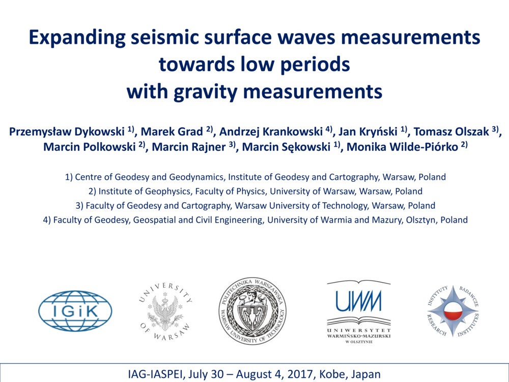
Dykowski P., M. Grad, A. Krankowski, J. Kryński, T. Olszak, M. Polkowski, M. Rajner, M. Sękowski i M. Wilde-Piórko. „Expanding seismic surface waves measurements towards low periods with gravity measurements”. Joint Symposium / J09. Geodesy and seismology general contributions. Kobe, Japonia.
- [bib]
@conference{Dykowski2017,
}eventtitle = {Joint Symposium / J09. Geodesy and seismology general contributions}, year = {2017}, title = {Expanding seismic surface waves measurements towards low periods with gravity measurements}, author = {Dykowski, Przemysław and Grad, Marek and Krankowski, Andrzej and Kryński, Jan and Olszak, Tomasz and Polkowski, Marcin and Rajner, Marcin and Sękowski, Marcin and Wilde-Piórko, Monika}, date = {2017-08-04}, month = {aug}, address = {Kobe, Japonia}, presenter = {Przemysław Dykowski}, - [streszczenie]
Seismic and gravity measurements are usually considered as separate scientific problems, although both are related to the same object – the Earth. Seismometers do not measure gravity field change and seismic events in gravity measurements are considered as disturbances and are usually removed from the records. The nature of tidal gravity measurements, especially superconductive gravimeters records, allows determining very long periods of seismic surface waves. Variety of broadband seismometers allow measuring surface waves up to period of 120-150 seconds, while superconducting gravimeters record surface waves up to 400-500 seconds. This is of great importance for structure studies, because waves of longer periods make possible studying deeper structures of the Earth. In this presentation, it has been shown how simultaneous seismic and gravity records at the same locations allow studying very long period surface waves. For test purposes 4 seismometer-gravimeter pairs have been deployed in Poland. These configurations are placed at three locations, Borowa Gora Geodetic-Geophysical Observatory (bg), Jozefoslaw Astronomical-Geodetic Observatory (joze), and Lamkowko Satellite Observatory (lamk). Three seismometers are paired with two types of LaCoste&Romberg spring gravimeters (et and model G) at all those Observatories. Additionally one seismometer is co-located on the same pillar with the iGrav-027 superconducting gravimeter at bg location. During the test period from December 2016 to January 2017 several large teleseismic events were observed with well-formed surface waves. Together with expected next events they should give dispersion curves for long surface waves, as well as periods of free oscillations. The correlation of a broadband seismometer signal with different types of gravimetric sensors gives a possibility to analyze gravimeter noise components, in the instrumental and microseismic domains.
- [bib]
2016
-
Rajner M. „Zastosowanie pływowych pomiarów grawimetrycznych w badaniach geodezyjnych, geofizycznych i geodynamicznych”. Seminarium zfl Instytutu Geofizyki uw.
- [bib]
@seminar{Rajner16igfuw,
}title = {Zastosowanie pływowych pomiarów grawimetrycznych w badaniach geodezyjnych, geofizycznych i geodynamicznych}, author = {Rajner, Marcin}, date = {2016-10-28T09:30:00}, month = {oct}, year = {2016}, venue = {gmach fizyki, uw}, eventtitle = {Seminarium zfl Instytutu Geofizyki uw}, address = {Warszawa}, presenter = {Marcin Rajner}, - [.pdf]
- [bib]
-
Tercjak M., M. Rajner i A. Brzeziński. „Investigation of phenomena influencing orientation of large ring laser gyroscope”. Współczesne problemy podstawowych osnów geodezyjnych w Polsce. Grybów.
- [bib]
@conference{Tercjak_Grybow_16,
}author = {Tercjak, Monika and Rajner, Marcin and Brzeziński, Aleksander}, eventdate = {2016-09-14/2016-09-16}, date = {2016-09-16}, month = {sep}, year = {2016}, title = {Investigation of phenomena influencing orientation of large ring laser gyroscope}, eventtitle = {Współczesne problemy podstawowych osnów geodezyjnych w Polsce}, address = {Grybów}, presenter = {Monika Tercjak},
- [bib]
-
Chwedorzewska K. J., H. Galera, S. Łapiński, M. E. Kowalska, M. Pasik, M. Rajner, E. Czyż, P. Bylina, A. Znój i M. Wódkiewicz. „First step to eradication of Poa annua L. from Arctowski Oasis (King George Island, South Shetlands, Antarctica)”. scar 2016 Open Science Conference. Kuala Lumpur, Malezja, isbn 978-0-948277-32-0.
- [bib]
@conference{Chwedorzewska16,
}eventtitle = {scar 2016 Open Science Conference}, eventdate = {2016-08-20/2016-08-30}, year = {2016}, address = {Kuala Lumpur, Malezja}, author = {Chwedorzewska, Katarzyna J. and Galera, Halina and Łapiński, Sławomir and Kowalska, Maria Elżbieta and Pasik, Mariusz and Rajner, Marcin and Czyż, Ewa and Bylina, Paweł and Znój, Anna and Wódkiewicz, Maciej}, title = {First step to eradication of Poa annua L. from Arctowski Oasis (King George Island, South Shetlands, Antarctica)}, isbn = {978-0-948277-32-0}, month = {aug}, presenter = {Katarzyna Chwedorzewska}, - [streszczenie]
Poa annua is the only flowering plant species that has established a breeding population in the maritime Antarctic, through repeated anthropogenic introduction. Annual bluegrass inhabits mainly anthropogenic sites, but recently has entered tundra communities. The functioning of P. annua in the Antarctic could not have been possible without adaptations that enable the plants to persist in the specific climatic conditions typical for this zone. Poa annua is highly adaptable to environmental stress and unstable habitats: huge phenotypic and genotypic variability, small size, plastic life cycle (life-history types ranging from annual to perennial forms). The spreading of P. annua in the Antarctic Peninsula region is a classic example of the expansion process following anthropogenic introduction of an invasive species, and illustrates the dangers to Antarctic terrestrial ecosystems that are associated with increasing human traffic. We report the first steps to eradicate the species after all the necessary initial research has been conducted. After detailed mapping a part of the ―Arctowski‖ population closest to a valuable moss carpet formation has been removed. We removed altogether 314 out of 1439 tussocks growing in the vicinity of Station buildings and all of the 49 tussocks growing in the forefield of Ecology Glacier. In subsequent years we will continue the eradication process and monitor the eradicated sites. This will provide valuable information on procedures concerning removal of alien species in the maritime Antarctic and will help making future informed decisions for other invasions in the region.
- [.pdf]
- [bib]
-
Rajner M. i T. Liwosz. „Analysis of seasonal position variation for selected gnss sites in Poland — Validation of results using loading modelling and grace data”. International Symposium on Geodesy and Geodynamics (Recent observations result and geophysical understanding). Tiencin, Chiny.
- [bib]
@conference{Rajner16prezentacjaTianjin,
}year = {2016}, title = {Analysis of seasonal position variation for selected gnss sites in Poland — Validation of results using loading modelling and grace data}, author = {Rajner, Marcin and Liwosz, Tomasz}, address = {Tiencin, Chiny}, eventtitle = {International Symposium on Geodesy and Geodynamics}, eventtitleaddon = {Recent observations result and geophysical understanding}, eventdate = {2016-07-22/2016-07-25}, date = {2016-07-23}, month = {jul}, presenter = {Marcin Rajner}, - [.pdf]
- [url]
- [bib]
-
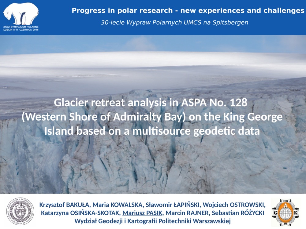
Bakuła K., M. E. Kowalska, S. Łapiński, K. Osińska–Skotak, M. Pasik, M. Rajner i S. Różycki. „Analiza recesji lodowców na obszarze aspa No. 128 (zachodnie wybrzeże Zatoki Admiralicji) na Wyspie Króla Jerzego na podstawie wieloźródłowych danych geodezyjnych”. xxxvi Sympozjum Polarne (Progress in polar research — new experiences and challenges). Lublin.
- [bib]
@conference{SympozjumPolarne2016_recesja,
}year = {2016}, date = {2016-06-10}, month = {jun}, title = {Analiza recesji lodowców na obszarze aspa No. 128 (zachodnie wybrzeże Zatoki Admiralicji) na Wyspie Króla Jerzego na podstawie wieloźródłowych danych geodezyjnych}, author = {Bakuła, Krzysztof and Kowalska, Maria Elżbieta and Łapiński, Sławomir and Osińska–Skotak, Katarzyna and Pasik, Mariusz and Rajner, Marcin and Różycki, Sebastian}, presenter = {Mariusz Pasik}, eventtitle = {xxxvi Sympozjum Polarne}, eventdate = {2016-06-08/2016-06-11}, eventtitleaddon = {Progress in polar research — new experiences and challenges}, address = {Lublin}, venue = {Wydział Nauk o Ziemi i Gospodarki Przestrzennej umcs}, - [streszczenie]
Referat przedstawia rezultaty analizy recesji lodowców na obszarze aspa (Antarctic Specially Protected Area) No. 128 - Western Shore of Admiralty Bay, zlokalizowanym w sąsiedztwie Polskiej Stacji Antarktycznej im. Henryka Arctowskiego na Wyspie Króla Jerzego. Analizę, obejmującą okres od powstania stacji do chwili obecnej, wykonano na podstawie archiwalnych opracowań kartograficznych oraz wieloźródłowych danych pozyskanych metodami geodezyjnych obejmującymi techniki gnss, naziemny skaning laserowy, zdjęcia fotogrametryczne z pułapu lotniczego i zobrazowania satelitarne. Praca prezentuje zmiany zasięgów, objętości oraz grubości pokrywy lodowej. Studia te w odróżnieniu od dotychczas publikowanych analiz dwuwymiarowych dotyczących tych lodowców, są próbą przedstawienia ich recesji w ujęciu trójwymiarowym. Badania wskazują nasilenie procesu cofania się lodowców w ostatniej dekadzie, szczególnie w przypadku tych uchodzących do morza. W literaturze tematu wśród przyczyn recesji wskazuje się ocieplenie klimatu. Na potwierdzenie wpływu tego procesu zaprezentowana została analiza danych meteorologicznych zarejestrowanych na Polskiej Stacji Antarktycznej.
- [bib]
-
Bakuła K., M. E. Kowalska, S. Łapiński, M. Pasik i M. Rajner. „Geodezyjne prace pomiarowo-badawcze w okolicy Polskiej Stacji Antarktycznej im. Henryka Arctowskiego podczas xxxix Polskiej Wyprawy Antarktycznej”. xxxvi Sympozjum Polarne (Progress in polar research — new experiences and challenges). Lublin.
- [bib]
@conference{SympozjumPolarne2016_prace_geodezyjne,
}year = {2016}, date = {2016-06-09}, month = {jun}, title = {Geodezyjne prace pomiarowo-badawcze w okolicy Polskiej Stacji Antarktycznej im. Henryka Arctowskiego podczas xxxix Polskiej Wyprawy Antarktycznej}, author = {Bakuła, Krzysztof and Kowalska, Maria Elżbieta and Łapiński, Sławomir and Pasik, Mariusz and Rajner, Marcin}, eventtitle = {xxxvi Sympozjum Polarne}, eventdate = {2016-06-08/2016-06-11}, eventtitleaddon = {Progress in polar research — new experiences and challenges}, venue = {Wydział Nauk o Ziemi i Gospodarki Przestrzennej umcs}, address = {Lublin}, - [streszczenie]
W opracowaniu zaprezentowano geodezyjne prace pomiarowo-badawcze, wykonane przez pracowników Wydziału Geodezji i Kartografii Politechniki Warszawskiej, w okolicy Polskiej Stacji Antarktycznej im. Henryka Arctowskiego, w trakcie xxxix Polskiej Wyprawy Antarktycznej na Wyspę Króla Jerzego w marcu 2015 r. Prace te miały na celu wykonanie dokumentacji geodezyjnej dla gospodarza stacji - Instytutu Biochemii i Biofizyki pan, niezbędnej do przygotowania projektu przebudowy lub budowy nowej stacji. W oparciu o przeprowadzone pomiary geodezyjne, wykonane za pomocą klasycznej tachimetrii oraz techniki gnss rtk, sporządzono mapę zasadniczą w skali 1:500 dla obszaru stacji i jej okolic. Dodatkowo wykonano inwentaryzację 3D obiektów stacji i jej bezpośredniego otoczenia z wykorzystaniem naziemnego skaningu laserowego. W oparciu o klasyczne dane i rezultaty skaningu opracowano wysokorozdzielcze numeryczne modele terenu stacji i jej sąsiedztwa. Są to pierwsze tak szczegółowe i dokładne opracowania, których treścią jest Polska Stacja. Praca przedstawia także precyzyjną osnowę geodezyjną założoną w okolicy stacji, której od powstania stacji do tej pory nie było. Ponadto, bazując na archiwalnych materiałach kartograficznych, przeprowadzono analizę zmian linii brzegowej, pod kątem oceny zagrożenia dla obiektów na terenie stacji.
- [bib]
-
Kowalska M. E., S. Łapiński, M. Pasik i M. Rajner. „Mapa zasadnicza Polskiej Stacji Antarktycznej im. Henryka Arctowskiego (Wyspa Króla Jerzego, Szetlandy Południowe)”. xxxvi Sympozjum Polarne (Progress in polar research — new experiences and challenges). Lublin.
- [bib]
@conference{SympozjumPolarne2016_mapa,
}year = {2016}, date = {2016-06-09}, month = {jun}, title = {Mapa zasadnicza Polskiej Stacji Antarktycznej im. Henryka Arctowskiego (Wyspa Króla Jerzego, Szetlandy Południowe)}, author = {Kowalska, Maria Elżbieta and Łapiński, Sławomir and Pasik, Mariusz and Rajner, Marcin}, eventtitle = {xxxvi Sympozjum Polarne}, venue = {Wydział Nauk o Ziemi i Gospodarki Przestrzennej umcs}, eventdate = {2016-06-08/2016-06-11}, address = {Lublin}, eventtitleaddon = {Progress in polar research — new experiences and challenges}, - [streszczenie]
Mapę zasadniczą Polskiej Stacji Antarktycznej im. Henryka Arctowskiego w skali 1:500 opracowano na podstawie danych pomiarowych zgromadzonych przez autorów w czasie wyprawy pomiarowo-badawczej na Wyspę Króla Jerzego w marcu 2015 r. Do pomiaru ponad 9 tys. punktów pomiarowych obejmujących obszar ok. 24 ha, zastosowano tachimetrię elektroniczną oraz technikę gnss rtk. Jako układ odniesienia zastosowano ITRF2008 (International Terrestrial Reference Frame) na epokę 2015.2, natomiast wysokości odniesiono do średniego poziomu morza w zatoce Admiralicji zaobserwowanego w latach 1998-1999. Opracowanie wykonano w systemie GEO-MAP w dwóch odwzorowaniach: Gaussa-Krügera z południkiem osiowym L o = 58o30’ W oraz utm (Universal Transverse Mercator) z południkiem osiowym L o = 57o W. Mapę w odwzorowaniu Gaussa-Krügera opracowaną w wersji polskojęzycznej, obejmującą teren stacji i jego sąsiedztwo, przekazano do dyspozycji Instytutu Biochemii i Biofizyki PAN oraz wykorzystano dla celów projektowych, związanych z przebudową stacji. Opracowanie w odwzorowaniu utm w wersji polskojęzycznej, obejmujące wyłącznie teren stacji, udostępniono na stronie stacji (http://www.arctowski.pl/arctowski/biblioteka/antar_mapki/arctowski_500.pdf). Mapę w tym samym odwzorowaniu w wersji anglojęzycznej umieszczono w międzynarodowym repozytorium opracowań kartograficznych scar Map Catalogue prowadzonym przez Australian Antarctic Data Centre. Jest ona dostępna do pobrania pod adresem http://data.aad.gov.au/aadc/mapcat/display_map.cfm?map_id=14496. Ze względu na symbolikę obiektów mapy zasadniczej, inną niż występująca na mapach topograficznych, udostępnione opracowania w odwzorowaniu utm opatrzono legendą.
- [bib]
-
Tercjak M., M. Rajner i A. Brzeziński. „Monitoring high frequency Earth rotation by ring laser: on modeling the local tilts”. 18th International Symposium on Geodynamics and Earth Tides (Intelligent Earth system sensing, scientific enquiry and discovery). Triest, Włochy.
- [bib]
@conference{Tercjak16triest,
}title = {Monitoring high frequency Earth rotation by ring laser: on modeling the local tilts}, author = {Tercjak, Monika and Rajner, Marcin and Brzeziński, Aleksander}, eventtitle = {18th International Symposium on Geodynamics and Earth Tides}, eventtitleaddon = {Intelligent Earth system sensing, scientific enquiry and discovery}, address = {Triest, Włochy}, year = {2016}, date = {2016-06-08}, month = {jun}, eventdate = {2016-06-05/2016-06-09}, presenter = {Monika Tercjak},
- [bib]
-
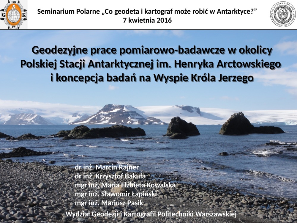
Bakuła K., S. Łapiński, M. E. Kowalska, M. Pasik i M. Rajner. „Geodezyjne prace pomiarowo-badawcze w okolicy Polskiej Stacji Antarktycznej im. Henryka Arctowskiego i koncepcja badań na Wyspie Króla Jerzego”. Seminarium polarne na Wydziale Geodezji i Kartografii (Co geodeta i kartograf może robić w obszarach polarnych?). Warszawa.
- [bib]
@conference{seminariumpolarnegik2016,
}author = {Bakuła, Krzysztof and Łapiński, Sławomir and Kowalska, Maria Elżbieta and Pasik, Mariusz and Rajner, Marcin}, title = {Geodezyjne prace pomiarowo-badawcze w okolicy Polskiej Stacji Antarktycznej im. Henryka Arctowskiego i koncepcja badań na Wyspie Króla Jerzego}, date = {2016-04-07T14:10:00}, month = {apr}, eventdate = {2016-04-07T14:00:00/2016-04-07T16:00:00}, eventtitle = {Seminarium polarne na Wydziale Geodezji i Kartografii}, eventtitleaddon = {Co geodeta i kartograf może robić w obszarach polarnych?}, presenter = {Mariusz Pasik}, venue = {Wydział Geodezji i Kartografii, Politechnika Warszawska}, year = {2016}, address = {Warszawa}, - [streszczenie]
W wystąpieniu zaprezentowane zostaną rezultaty prac pomiarowo-badawczych wykonanych, w okolicy Polskiej Stacji Antarktycznej im. Henryka Arctowskiego, w trakcie wyprawy na Wyspę Króla Jerzego w marcu 2015 r. Prace te objęły założenie osnowy geodezyjnej, pomiary sytuacyjno-wysokościowe i opracowanie mapy zasadniczej w skali 1:500, a także skaning laserowy obiektów stacji i jej okolic oraz wykonanie numerycznych modeli wysokościowych terenu Stacji. Referat przedstawi także inne badania polarne podjęte przez uczestników wyprawy m.in. monitoring lodowców oraz koncepcję badań, które Wydział zamierza podjąć w Antarktyce.
- [url]
- [bib]
-
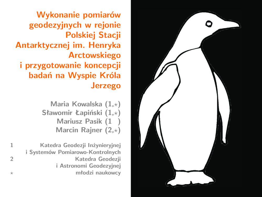
Kowalska M. E., S. Łapiński, M. Pasik i M. Rajner. „Wykonanie pomiarów geodezyjnych w rejonie Polskiej Stacji Antarktycznej im. Henryka Arctowskiego i przygotowanie koncepcji badań na Wyspie Króla Jerzego”.
- [bib]
@conference{grantdziekanski2015prezentacja,
}author = {Kowalska, Maria Elżbieta and Łapiński, Sławomir and Pasik, Mariusz and Rajner, Marcin}, date = {2016-03-10}, month = {mar}, year = {2016}, title = {Wykonanie pomiarów geodezyjnych w rejonie Polskiej Stacji Antarktycznej im. Henryka Arctowskiego i przygotowanie koncepcji badań na Wyspie Króla Jerzego}, note = {Sprawozdanie z grantu/statutu 2015}, presenter = {Marcin Rajner}, - [.pdf]
- [bib]


2015
-
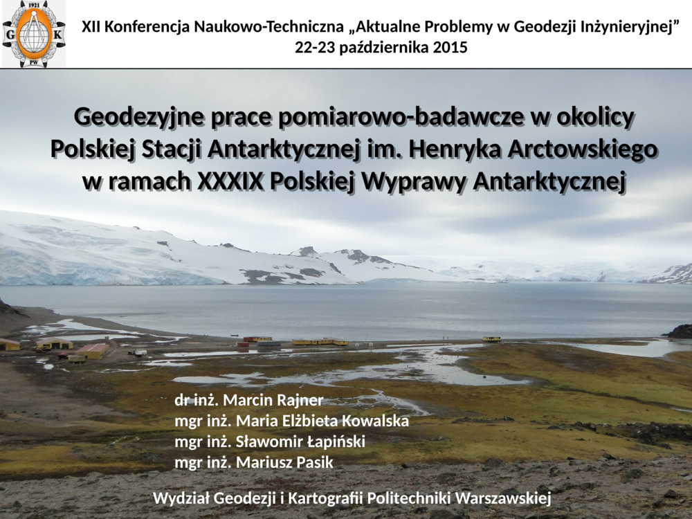
Kowalska M. E., S. Łapiński, M. Pasik, M. Rajner i P. Bylina. „Geodezyjne prace pomiarowo-badawcze w okolicy Polskiej Stacji Antarktycznej im. Henryka Arctowskiego w ramach xxxix Polskiej Wyprawy Antarktycznej”. xii Konferencja Naukowo-Techniczna Aktualne Problemy w Geodezji Inżynieryjnej. Warszawa/Serock.
- [bib]
@conference{Pasik2015,
}date = {2015-10-22}, month = {oct}, year = {2015}, author = {Kowalska, Maria Elżbieta and Łapiński, Sławomir and Pasik, Mariusz and Rajner, Marcin and Bylina, Paweł}, title = {Geodezyjne prace pomiarowo-badawcze w okolicy Polskiej Stacji Antarktycznej im. Henryka Arctowskiego w ramach xxxix Polskiej Wyprawy Antarktycznej}, eventtitle = {xii Konferencja Naukowo-Techniczna Aktualne Problemy w Geodezji Inżynieryjnej}, eventdate = {2015-10-22/2015-10-23}, address = {Warszawa/Serock}, presenter = {Mariusz Pasik}, - [.pdf]
- [url]
- [bib]
-
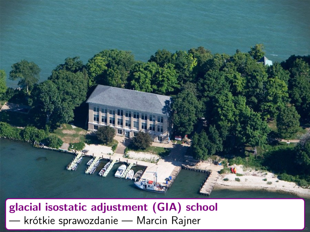
Rajner M. „Glacial Isostatic Adjustment Training School — krótkie sprawozdanie”. Badania geodynamiczne z wykorzystaniem współczesnych osiągnięć geodezji. Józefosław.
- [bib]
@conference{Rajner2015joze,
}title = {Glacial Isostatic Adjustment Training School — krótkie sprawozdanie}, author = {Rajner, Marcin}, eventtitle = {Badania geodynamiczne z wykorzystaniem współczesnych osiągnięć geodezji}, venue = {Obserwatorium Astro-Geodezyjne pw}, address = {Józefosław}, year = {2015}, eventdate = {2015-10-19/2015-10-20}, date = {2015-10-19}, month = {oct}, presenter = {Marcin Rajner}, - [streszczenie]
Uczestnikom seminarium przedstawione zostaną informacje dotyczące szkoły gia, która odbyła się we wrześniu br.
- [.pdf]
- [url]
- [bib]
-
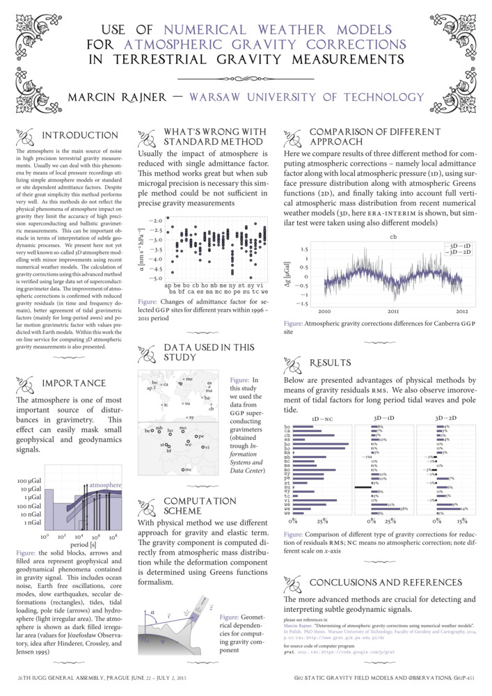
Rajner M. „Use of numerical weather models for atmospheric gravity corrections in terrestrial gravity measurements”. 26th General Assembly of the International Union of Geodesy and Geophysics (Earth and Environmental Sciences for Future Generations). Praga, Czechy.
- [bib]
@conference{Rajner2015_iugg,
}author = {Rajner, Marcin}, title = {Use of numerical weather models for atmospheric gravity corrections in terrestrial gravity measurements}, eventdate = {2015-06-22/2015-07-02}, date = {2015-06-30}, month = {jun}, year = {2015}, venue = {Praskie Centrum Konferencyjne, 5. kvetna 65 140 00 Praga 4}, address = {Praga, Czechy}, eventtitle = {26th General Assembly of the International Union of Geodesy and Geophysics}, eventtitleaddon = {Earth and Environmental Sciences for Future Generations}, - [streszczenie]
The atmosphere is the main source of noise in high precision terrestrial gravity measurements. Usually we can deal with this phenomena by means of local pressure recordings utilizing simple atmosphere models or standard or site dependent admittance factors. Despite of their great simplicity this method performs very well. As this methods do not reflect the physical phenomena of atmosphere impact on gravity they limit the accuracy of high precision superconducting and ballistic gravimetric measurements. This can be important obstacle in terms of interpretation of subtle geodynamic processes. We present here not yet very well known so-called 3D atmosphere modelling with minor improvements using recent numerical weather models. The calculation of gravity corrections using this advanced method is verified using large data set of superconducting gravimeter data. The improvement of atmospheric corrections is confirmed with reduced gravity residuals (in time and frequency domain), better agreement of tidal gravimetric factors (mainly for long-period awes) and polar motion gravimetric factor with values predicted with Earth models. Within this work the on-line service for computing 3D atmospheric gravity measurements is also presented.
- [.pdf]
- [url]
- [bib]
-
Adamek A., M. Rajner, A. Adamek i M. E. Kowalska. „Opracowanie metodyki inwentaryzacji przestrzennej systemów drenażowych lodowców z wykorzystaniem technologii skanowania laserowego”. Sprawozdanie z grantu dziekańskiego 2014.
- [bib]
@conference{spitsbergen2014grantdziekanskiprezentacja,
}author = {Adamek, Artur and Rajner, Marcin and Adamek, Anna and Kowalska, Maria Elżbieta}, year = {2015}, title = {Opracowanie metodyki inwentaryzacji przestrzennej systemów drenażowych lodowców z wykorzystaniem technologii skanowania laserowego}, subtitle = {Sprawozdanie z grantu dziekańskiego 2014}, date = {2015-03-05}, month = {mar}, presenter = {Marcin Rajner}, - [.pdf]
- [bib]
2014
-
Rajner M. „Wyznaczanie atmosferycznych poprawek grawimetrycznych na podstawie numerycznych modeli pogody”. Obrona rozprawy doktorskiej.
- [bib]
@conference{Rajnerdr_prezentacja,
}author = {Rajner, Marcin}, title = {Wyznaczanie atmosferycznych poprawek grawimetrycznych na podstawie numerycznych modeli pogody}, booktitle = {Obrona rozprawy doktorskiej}, year = {2014}, school = {Politechnika Warszawska, Wydział Geodezji i Kartografii}, eventdate = {2014-11-07}, presenter = {Marcin Rajner}, month = {nov}, - [.pdf]
- [url]
- [podstrona..]
- [bib]
-
Rajner M. „Wpływ stosowania klasycznych redukcji atmosferycznych na stabilność precyzyjnych osnów grawimetrycznych”. Realizacja Osnów Geodezyjnych a Problemy Geodynamiki. Grybów.
- [bib]
@conference{Rajner2014_grybow,
}date = {2014-09-26}, month = {sep}, year = {2014}, author = {Rajner, Marcin}, title = {Wpływ stosowania klasycznych redukcji atmosferycznych na stabilność precyzyjnych osnów grawimetrycznych}, eventtitle = {Realizacja Osnów Geodezyjnych a Problemy Geodynamiki}, eventdate = {2014-09-25/2014-09-27}, address = {Grybów}, presenter = {Marcin Rajner}, - [streszczenie]
Dokładność współczesnych grawimetrów balistycznych pozwala wyznaczać wartości przyspieszenia siły ciężkości na poziomie pojedynczych mikrogali. Powoduje to również konieczność nadzwyczaj starannego modelowania wpływu różnych czynników wpływających na pomiary przyspieszenia ziemskiego. Standardowo stosowane redukcje atmosferyczne biorą pod uwagę tylko lokalne wartości ciśnienia atmosferycznego i opierają się na statystyce. W tej pracy pokażę, że uwzględnianie fizycznego charakteru zjawiska wpływu atmosfery na przyspieszenie siły ciężkości może powodować rozbieżności w stosunku do klasycznych metod na poziomie dokładności samych pomiarów, a tym samym stosowanie złożonych metod wyznaczania poprawek atmosferycznych jest niezbędne w celu pełnego wykorzystania potencjału grawimetrów balistycznych. Dobór metody opracowania obserwacji przekłada się również na stabilność zakładanych precyzyjnych osnów grawimetrycznych.
- [.pdf]
- [bib]
2013
-
Brzeziński A. i M. Rajner. „Estimation of the Chandler wobble parameters by the use of the Kalman deconvolution filter”. Journées 2013 Systèmes de Référence Spatio-Temporels (Scientific developments from highly accurate space-time reference systems). Paryż, Francja.
- [bib]
@conference{Brzezinski2013_journee,
}date = {2013-09-17}, month = {sep}, year = {2013}, author = {Brzeziński, Aleksander and Rajner, Marcin}, title = {Estimation of the Chandler wobble parameters by the use of the Kalman deconvolution filter}, eventtitle = {Journées 2013 Systèmes de Référence Spatio-Temporels}, eventdate = {2013-09-16/2013-09-18}, address = {Paryż, Francja}, presenter = {Aleksander Brzeziński}, eventtitleaddon = {Scientific developments from highly accurate space-time reference systems}, - [streszczenie]
The parameters of the Chandler wobble (cw), the frequency F (or, equivalently, the period T = 1/F) and the quality factor Q, are important for studying global dynamics of the Earth because they define the equation describing geophysical excitation of polar motion and are closely related to various geophysical parameters. Our purpose here is to estimate of the cw parameters based on the stochastic models of polar motion and geophysical excitation data. We apply the Kalman deconvolution filter developed by Brzezinski (1992, manuscripta geodaetica 17: 3-20). This filter can be used to analyze either the polar motion data alone, or simultaneously the polar motion and the excitation data, in order to estimate the unknown residual excitation. By imposing the minimum variance constraint upon the estimated excitation we can find the best value of the resonant parameters F and Q. We will show here some results based on different available sets of polar motion and geophysical excitation data. The estimated cw parameters will be compared to each other as well as to the results based on the alternative algorithms.
- [url]
- [bib]
-
Brzeziński A. i M. Rajner. „Estimation of the Chandler wobble parameters based on the stochastic modeling of the observed free polar motion and its excitation”. iag Scientific Assembly (iag 150 years). Poczdam, Niemcy.
- [bib]
@conference{Brzezinski2013_iag,
}date = {2013-09-03}, month = {sep}, year = {2013}, author = {Brzeziński, Aleksander and Rajner, Marcin}, title = {Estimation of the Chandler wobble parameters based on the stochastic modeling of the observed free polar motion and its excitation}, eventtitle = {iag Scientific Assembly}, eventtitleaddon = {iag 150 years}, eventdate = {2013-09-01/2013-09-06}, venue = {Dorint Hotel}, address = {Poczdam, Niemcy}, presenter = {Brzeziński, Aleksander}, - [streszczenie]
The Chandler wobble (cw) is the most important rotational eigenmode of the Earth. Its parameters, the frequency F (or, equivalently, the period T=1/F) and the quality factor Q, are important for studying global dynamics of the Earth because they define the equation describing geophysical excitation of polar motion and are closely related to various geophysical parameters. Our purpose here is to derive the improved estimate of the cw parameters by using the stochastic models of the polar motion and geophysical excitation data. We apply the following three algorithms of data analysis: 1) Autoregressive (ar) model of the observed polar motion fitted by imposing the maximum entropy condition; 2) Autoregressive integrated moving-average (arima) model which takes into account the influence of the polar motion observation errors, estimated by applying the maximum likelihood condition; 3) Kalman filter developed on the base of stochastic models of both the polar motion observations and the excitation data. This filter can be applied to analyze either the polar motion data alone or simultaneously the polar motion and geophysical excitation data. These three algorithms are used in this work to derive the cw parameters from analysis of different available sets of polar motion and geophysical excitation data. The estimated values of F and Q are compared to each other as well as to the results known from the literature.
- [url]
- [bib]
-
Rajner M. „grat — open source software for computing atmospheric gravity correction using numerical weather models”. iag Scientific Assembly (iag 150 years). Poczdam, Niemcy.
- [bib]
@conference{Rajner2013_iag,
}date = {2013-09-01}, month = {sep}, year = {2013}, author = {Rajner, Marcin}, title = {grat — open source software for computing atmospheric gravity correction using numerical weather models}, eventtitle = {iag Scientific Assembly}, eventtitleaddon = {iag 150 years}, eventdate = {2013-09-01/2013-09-06}, venue = {Dorint Hotel}, address = {Poczdam, Niemcy}, note = {poster wyróżniony}, - [streszczenie]
In order to fully utilize the accuracy of modern ballistic and superconducting gravimeters we have to be able to remove all sources of disturbances in the measurements. One of the main effect is impact of atmosphere masses on surface gravity values. Usually we take this into account using pressure measurements along with single admittance factor. If the continuous gravity measurements at the site are at our disposal we can determine this factor by means of statistical methods. These methods perform very well and major part of atmospheric disturbances can be removed. Nevertheless these methods do not reflect the physical phenomena and are not adequate when accuracy of a few microGal is needed. This can be extremely important when one uses gravity measurements for tectonic studies. In this paper I introduce a new computer program (called grat) to facilitate computation of atmospheric gravity correction making extensive use of numerical weather models. Using meteorological parameters we can perform computation using 2D method (surface pressure with exponential pressure changes with height) and 3D method (numerical integration for vertical layers). We can compute separate the deformation as well as attraction terms using different Earth models and numerical weather models. We can also add the temperature, topography and Inverted Barometer effect. All possible combinations make this flexible and versatile tool. In opposition to existing services (atmacs and loading.u-strasbg.fr) we are not restricted for specific sites and we can perform computation according to our needs with use of plethora of switches. All sources of program (fully written in Fortran90 with elements of Fortran2003) are freely available. The usefulness of this program will be presented with comparison to other methods and services and with comparison with real data from absolute and relative gravimeters.
- [.pdf]
- [url]
- [bib]
-
Rajner M. „Wyznaczanie atmosferycznych poprawek grawimetrycznych z uwzględnieniem fizycznego charakteru zjawiska wpływu atmosfery na pomiary siły ciężkości”. Badania geodynamiczne z wykorzystaniem współczesnych osiągnięć geodezji. Józefosław.
- [bib]
@conference{Rajner2013_jozefoslaw,
}date = {2013-06-18}, month = {jun}, year = {2013}, author = {Rajner, Marcin}, title = {Wyznaczanie atmosferycznych poprawek grawimetrycznych z uwzględnieniem fizycznego charakteru zjawiska wpływu atmosfery na pomiary siły ciężkości}, eventtitle = {Badania geodynamiczne z wykorzystaniem współczesnych osiągnięć geodezji}, eventdate = {2013-06-17/2013-06-18}, address = {Józefosław}, presenter = {Marcin Rajner}, - [.pdf]
- [bib]
-
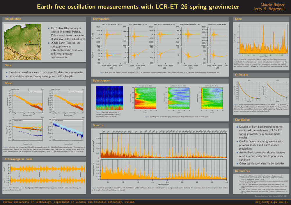
Rajner M. „Still valuable measurements taken with spring gravimeter — results from Józefosław observatory”. 17th International Symposium on Earth Tides (Understand the Earth). Warszawa.
- [bib]
@conference{Rajner13ets,
}title = {Still valuable measurements taken with spring gravimeter — results from Józefosław observatory}, author = {Rajner, Marcin}, eventtitle = {17th International Symposium on Earth Tides}, eventtitleaddon = {Understand the Earth}, eventdate = {2013-04-15/2013-04-19}, date = {2013-04-15}, month = {apr}, year = {2013}, venue = {cgs wat}, address = {Warszawa}, - [streszczenie]
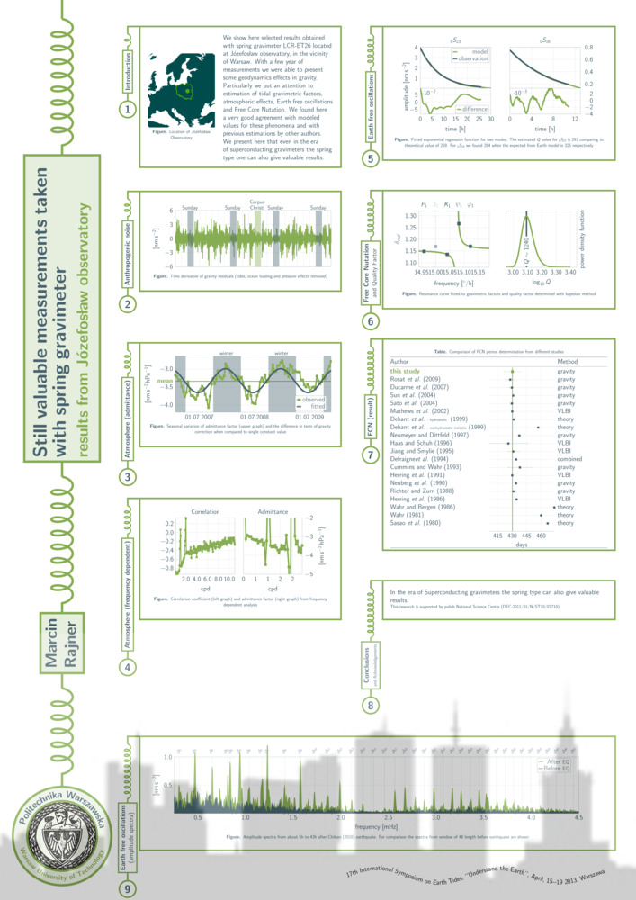
We show here selected results obtained with spring gravimeter lcr-et26 located at Józefosław observatory, in the vicinity of Warsaw. With a few year of measurements we were able to present some geodynamics effects in gravity. Particularly we put an attention to estimation of tidal gravimetric factors, ocean tidal loading, atmospheric effects, Earth free oscillations and Free Core Nutation. We found here a very good agreement with modeled values for these phenomena and with previous estimations by other authors. We present here that even in the era of superconducting gravimeters the spring type one can also give valuable results.
- [.pdf]
- [url]
- [bib]
-
Rajner M. „Wyznaczanie atmosferycznych poprawek grawimetrycznych na podstawie numerycznych modeli pogody”. Sprawozdanie z grantu dziekańskiego 2012.
- [bib]
@conference{grantdziekanski2012prezentacja,
}author = {Rajner, Marcin}, year = {2013}, title = {Wyznaczanie atmosferycznych poprawek grawimetrycznych na podstawie numerycznych modeli pogody}, subtitle = {Sprawozdanie z grantu dziekańskiego 2012}, presenter = {Marcin Rajner}, - [.pdf]
- [bib]

2012
-
Brzeziński A. i M. Rajner. „Stochastic modeling of the Chandler wobble and its excitation”. agu Fall Meeting, agu Fall Meeting Abstracts. San Francisco, ca, usa.
- [bib]
@conference{Brzezinski2012,
}author = {Brzeziński, Aleksander and Rajner, Marcin}, title = {Stochastic modeling of the Chandler wobble and its excitation}, eventtitle = {agu Fall Meeting}, address = {San Francisco, ca, usa}, date = {2012-12-05}, month = {dec}, year = {2012}, eventdate = {2012-12-05/2012-12-09}, presenter = {Aleksander Brzeziński}, language = {english}, booktitle = {agu Fall Meeting Abstracts},
- [bib]
-
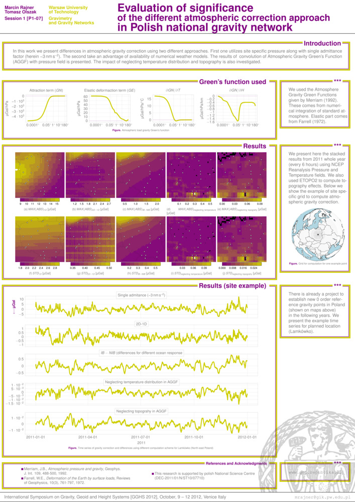
Rajner M. i T. Olszak. „Evaluation of significance of the different atmospheric correction approach in Polish national gravity network”. International Symposium on Gravity, Geoid and Height Systems. Wenecja, Włochy.
- [bib]
@conference{Rajner2012wenecja,
}author = {Rajner, Marcin and Olszak, Tomasz}, year = {2012}, title = {Evaluation of significance of the different atmospheric correction approach in Polish national gravity network}, eventtitle = {International Symposium on Gravity, Geoid and Height Systems}, eventdate = {2012-10-09/2012-10-12}, date = {2012-10-09}, month = {oct}, venue = {San Servolo}, address = {Wenecja, Włochy}, - [.pdf]
- [bib]
-
Rajner M. i T. Liwosz. „Zmiany wysokości powodowane przez obciążenia atmosferyczne w regionalnej sieci stacji gnss”. Satelitarne metody wyznaczania pozycji we współczesnej geodezji i nawigacji. Warszawa.
- [bib]
@conference{Rajnercbk2012,
}author = {Rajner, Marcin and Liwosz, Tomasz}, year = {2012}, title = {Zmiany wysokości powodowane przez obciążenia atmosferyczne w regionalnej sieci stacji gnss}, eventtitle = {Satelitarne metody wyznaczania pozycji we współczesnej geodezji i nawigacji}, eventdate = {2012-09-13/2012-09-15}, date = {2012-09-14}, month = {sep}, address = {Warszawa}, venue = {Centrum Badań Kosmicznych}, presenter = {Marcin Rajner}, - [.pdf]
- [bib]
-
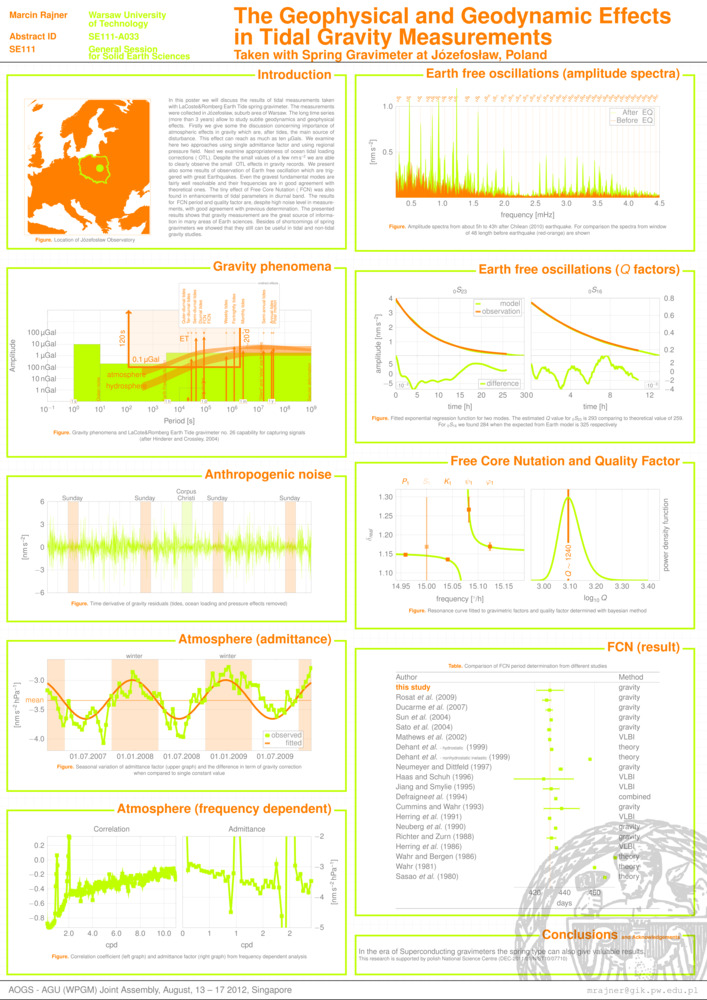
Rajner M. „The geophysical and geodynamic effects in tidal gravity measurements taken with spring gravimeter at Józefosław, Poland”. aogs–agu (wpgm) Joint Assembly. Singapur.
- [bib]
@conference{Rajnersingapur2012,
}author = {Rajner, Marcin}, year = {2012}, title = {The geophysical and geodynamic effects in tidal gravity measurements taken with spring gravimeter at Józefosław, Poland}, eventtitle = {aogs–agu (wpgm) Joint Assembly}, address = {Singapur}, eventdate = {2012-08-13/2012-08-17}, date = {2012-08-15}, month = {aug}, venue = {World Resort Sentosa}, - [.pdf]
- [bib]
-
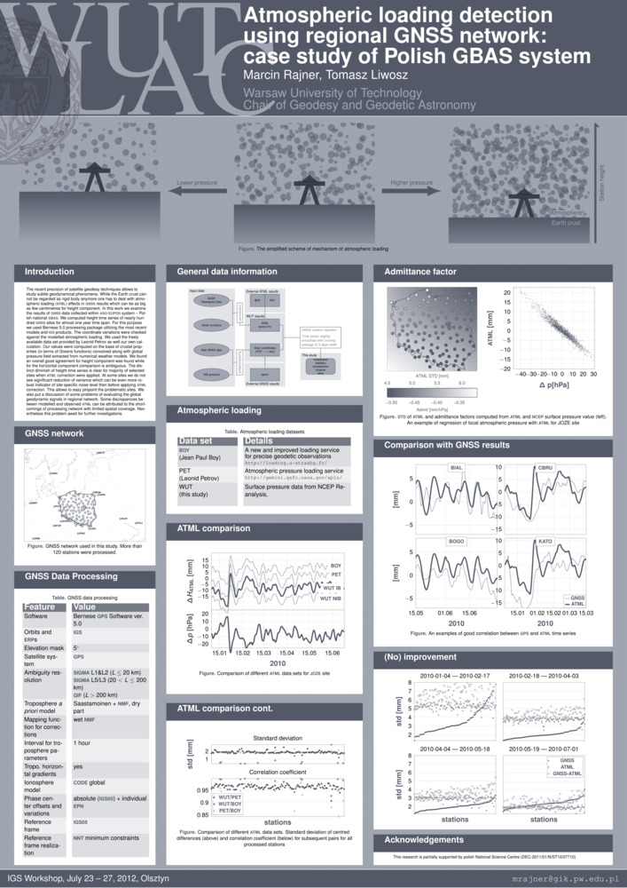
Rajner M. i T. Liwosz. „Atmospheric loading detection using regional gnss network: case study of Polish gbas system”. igs Workshop. Olsztyn.
- [bib]
@conference{RajnerLiwoszIGS2012,
}author = {Rajner, Marcin and Liwosz, Tomasz}, year = {2012}, title = {Atmospheric loading detection using regional gnss network: case study of Polish gbas system}, eventtitle = {igs Workshop}, eventdate = {2012-07-23/2012-07-27}, month = {jul}, address = {Olsztyn}, venue = {uwm}, - [.pdf]
- [bib]
-
Kruczyk M., T. Liwosz i M. Rajner. „Wybrane metody wykorzystania gps w badaniach polarnych”. xxxiv Sympozjum Polarne. Sosnowiec.
- [bib]
@conference{Kruczyk12,
}author = {Kruczyk, Michał and Liwosz, Tomasz and Rajner, Marcin}, year = {2012}, title = {Wybrane metody wykorzystania gps w badaniach polarnych}, eventtitle = {xxxiv Sympozjum Polarne}, address = {Sosnowiec}, eventdate = {2012-06-14/2012-06-16}, date = {2012-06-16}, month = {jun}, presenter = {Michał Kruczyk},
- [bib]
-
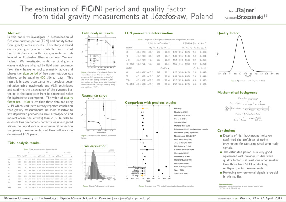
Rajner M. i A. Brzeziński. „The estimation of Free Core Nutation period and quality factor from tidal gravity measurements at Józefosław, Poland”. egu General Assembly, egu General Assembly Conference Abstracts, redaktor A. Abbasi i N. Giesen, 14:14253. Wiedeń, Austria.
- [bib]
@conference{RajnerBrzezinskiegu2012,
}author = {Rajner, Marcin and Brzeziński, Aleksander}, title = {The estimation of Free Core Nutation period and quality factor from tidal gravity measurements at Józefosław, Poland}, year = {2012}, month = {apr}, eventtitle = {egu General Assembly}, address = {Wiedeń, Austria}, eventdate = {2012-04-22/2012-04-27}, presenter = {Marcin Rajner}, booktitle = {egu General Assembly Conference Abstracts}, series = {egu General Assembly Conference Abstracts}, volume = {14}, editor = {Abbasi, A. and Giesen, N.}, pages = {14253}, - [.pdf]
- [bib]
-
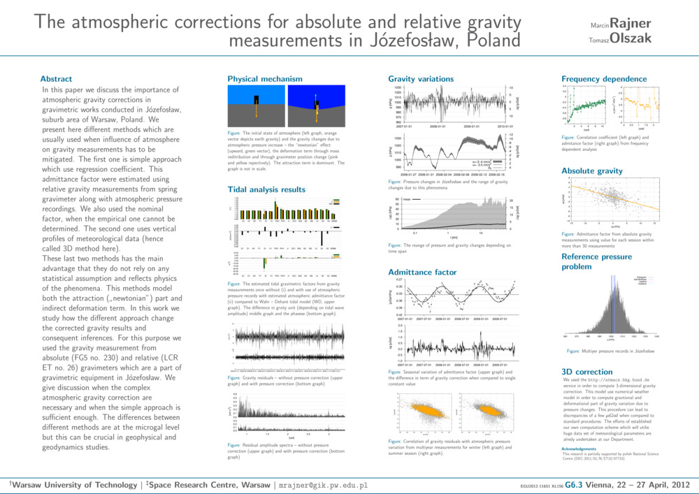
Rajner M. i T. Olszak. „The atmospheric corrections for absolute and relative gravity measurements in Józefosław, Poland”. egu General Assembly, egu General Assembly Conference Abstracts, redaktor A. Abbasi i N. Giesen, 14:11651. Wiedeń, Austria.
- [bib]
@conference{RajnerOlszakegu2012,
}author = {Rajner, Marcin and Olszak, Tomasz}, title = {The atmospheric corrections for absolute and relative gravity measurements in Józefosław, Poland}, eventtitle = {egu General Assembly}, address = {Wiedeń, Austria}, eventdate = {2012-04-22/2012-04-27}, booktitle = {egu General Assembly Conference Abstracts}, year = {2012}, month = {apr}, volume = {14}, editor = {Abbasi, A. and Giesen, N.}, pages = {11651}, - [.pdf]
- [bib]
2011
-
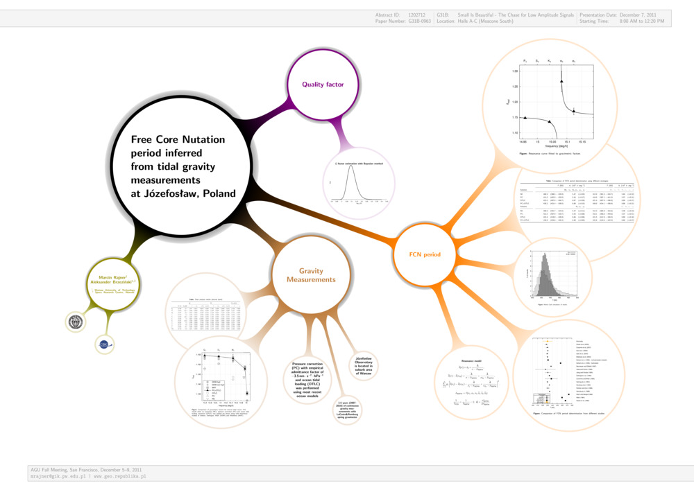
Rajner M. i A. Brzeziński. „Free Core Nutation period inferred from tidal gravity measurements at Józefosław, Poland”. agu Fall Meeting, agu Fall Meeting Abstracts. San Francisco, ca, usa.
- [bib]
@conference{RajnerBrzezinskiAGU11,
}author = {Rajner, Marcin and Brzeziński, Aleksander}, year = {2011}, title = {Free Core Nutation period inferred from tidal gravity measurements at Józefosław, Poland}, eventtitle = {agu Fall Meeting}, venue = {Moscon Centre}, address = {San Francisco, ca, usa}, eventdate = {2011-12-05/2011-12-09}, month = {dec}, booktitle = {agu Fall Meeting Abstracts}, - [.pdf]
- [bib]
-
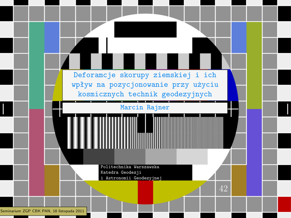
Rajner M. „Deformacje skorupy ziemskiej i ich wpływ na pozycjonowanie przy użyciu kosmicznych technik geodezyjnych”. Seminarium Zakładu Geodezji Planetarnej cbk.
- [bib]
@seminar{Rajner2011cbk,
}author = {Rajner, Marcin}, year = {2011}, title = {Deformacje skorupy ziemskiej i ich wpływ na pozycjonowanie przy użyciu kosmicznych technik geodezyjnych}, eventtitle = {Seminarium Zakładu Geodezji Planetarnej cbk}, venue = {cbk pan}, address = {Warszawa}, date = {2011-11-18}, month = {nov}, presenter = {Marcin Rajner}, - [.pdf]
- [bib]
-
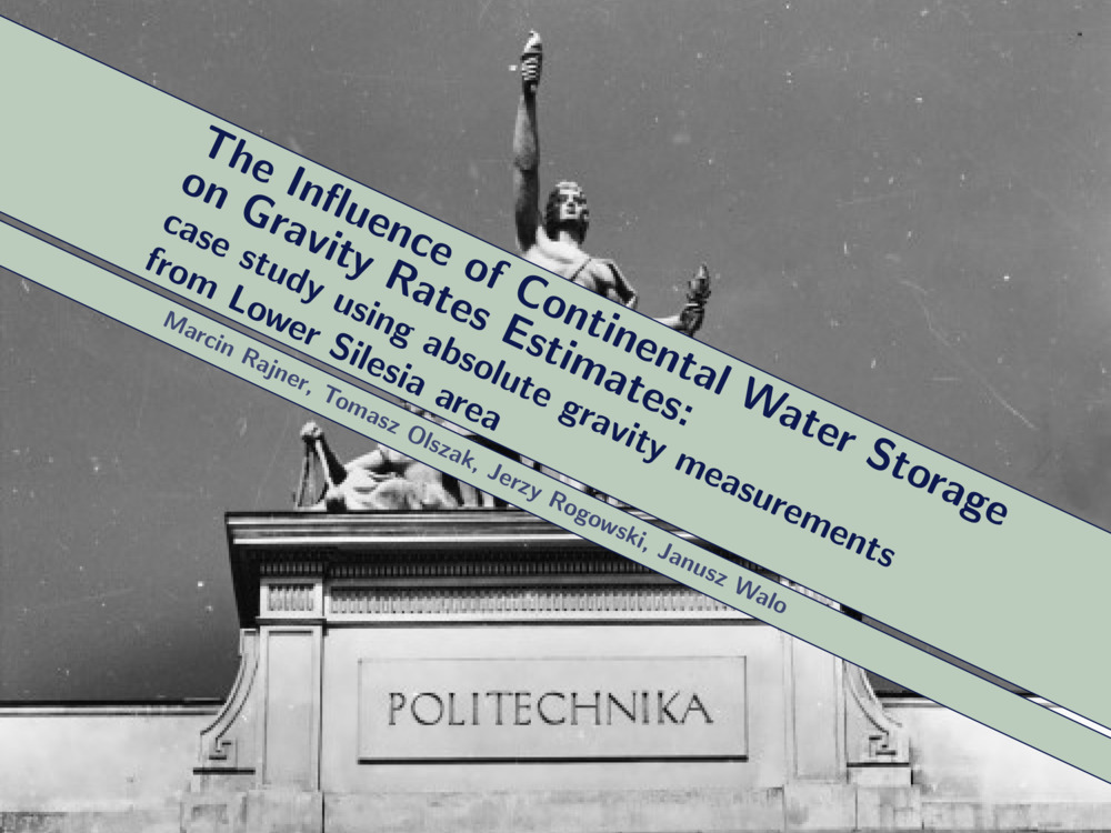
Rajner M., T. Olszak, J. B. Rogowski i J. Walo. „The influence of continental water storage on gravity rates estimates: case study using absolute gravity measurements from Lower Silesia area”. On recent geodynamics of the Sudeten and adjacent areas. Jugowice.
- [bib]
@conference{Rajner2011jugowiceprezentacja,
}author = {Rajner, Marcin and Olszak, Tomasz and Rogowski, Jerzy B. and Walo, Janusz}, year = {2011}, title = {The influence of continental water storage on gravity rates estimates: case study using absolute gravity measurements from Lower Silesia area}, eventtitle = {On recent geodynamics of the Sudeten and adjacent areas}, address = {Jugowice}, eventdate = {2011-10-20/2011-10-22}, date = {2011-10-21}, month = {oct}, presenter = {Marcin Rajner}, - [.pdf]
- [bib]
-
Rajner M. „Deformacje Ziemi”. Czy współczesna geodezja może istnieć bez geodynamiki? Józefosław.
- [bib]
@conference{Rajner2011joze,
}author = {Rajner, Marcin}, year = {2011}, title = {Deformacje Ziemi}, eventtitle = {Czy współczesna geodezja może istnieć bez geodynamiki?}, address = {Józefosław}, eventdate = {2011-10-17/2011-10-18}, date = {2011-10-18}, month = {oct}, presenter = {Marcin Rajner}, - [.pdf]
- [bib]
-
Rajner M. i A. Brzeziński. „Wyznaczenie okresu swobodnej nutacji jądra na podstawie pomiarów grawimetrycznych w Józefosławiu”. Czy współczesna geodezja może istnieć bez geodynamiki? Józefosław.
- [bib]
@conference{RajnerBrzezinski11joze,
}author = {Rajner, Marcin and Brzeziński, Aleksander}, title = {Wyznaczenie okresu swobodnej nutacji jądra na podstawie pomiarów grawimetrycznych w Józefosławiu}, year = {2011}, eventtitle = {Czy współczesna geodezja może istnieć bez geodynamiki?}, address = {Józefosław}, eventdate = {2011-10-17/2011-10-18}, date = {2011-10-18}, month = {oct}, presenter = {Marcin Rajner}, - [.pdf]
- [bib]
-
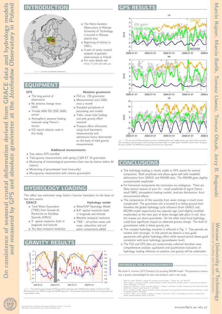
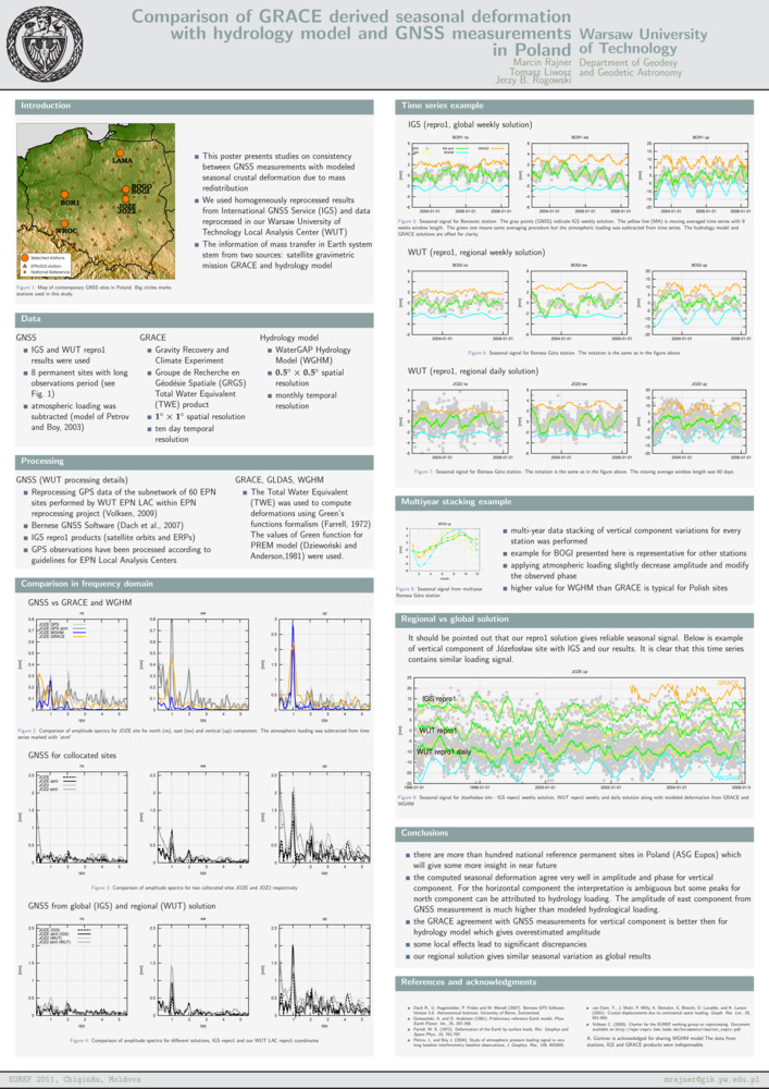
Rajner M., M. Barlik, T. Liwosz, T. Olszak i J. B. Rogowski. „On consistence of seasonal crustal deformation derived from grace data and hydrology models and measured by gps and absolute gravimeter at the Józefosław observatory in Poland”. iugg. Melbourne, Australia.
- [bib]
@conference{RajnerIUGG11,
}author = {Rajner, Marcin and Barlik, Marcin and Liwosz, Tomasz and Olszak, Tomasz and Rogowski, Jerzy B.}, year = {2011}, title = {On consistence of seasonal crustal deformation derived from grace data and hydrology models and measured by gps and absolute gravimeter at the Józefosław observatory in Poland}, eventtitle = {iugg}, address = {Melbourne, Australia}, eventdate = {2011-06-28/2011-07-07}, month = {jul}, presenter = {Tomasz Liwosz}, - [.pdf]
- [bib]
-
Rajner M., T. Liwosz i J. B. Rogowski. „Analiza sezonowych zmian pozycji wybranych stacji gnss. Weryfikacja wyników na podstawie danych misji satelitarnej grace”. Satelitarne metody wyznaczania pozycji we współczesnej geodezji i nawigacji. Wrocław.
- [bib]
@conference{RajneretalWroclaw11,
}author = {Rajner, Marcin and Liwosz, Tomasz and Rogowski, Jerzy B.}, title = {Analiza sezonowych zmian pozycji wybranych stacji gnss. Weryfikacja wyników na podstawie danych misji satelitarnej grace}, eventtitle = {Satelitarne metody wyznaczania pozycji we współczesnej geodezji i nawigacji}, address = {Wrocław}, eventdate = {2011-06-02/2011-06-04}, date = {2011-06-03}, month = {jun}, year = {2011}, presenter = {Marcin Rajner}, - [.pdf]
- [bib]
-
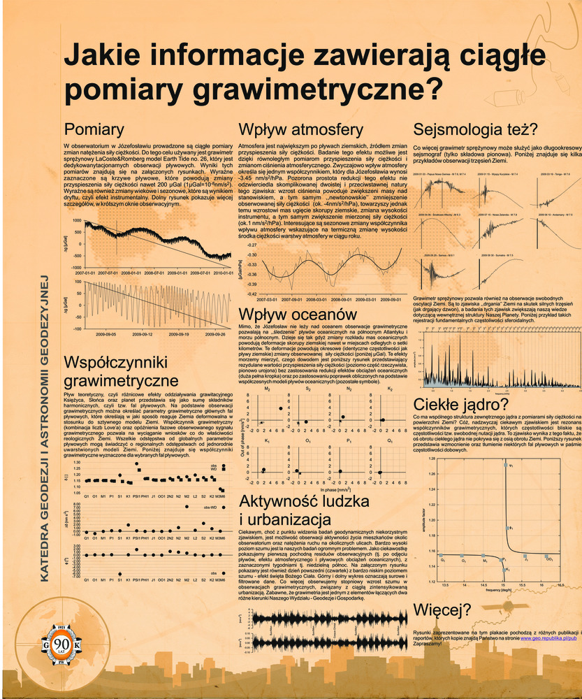
Rajner M. „Jakie informacje zawierają ciągłe pomiary grawimetryczne?” 90-lecie Wydziału gik. Warszawa.
- [bib]
@conference{Rajner90latGiK,
}author = {Rajner, Marcin}, year = {2011}, title = {Jakie informacje zawierają ciągłe pomiary grawimetryczne?}, eventtitle = {90-lecie Wydziału gik}, address = {Warszawa}, eventdate = {2011-05-27}, date = {2011-05-27}, month = {may}, - [.pdf]
- [bib]
-
Rajner M., T. Liwosz i J. B. Rogowski. „Comparison of grace derived seasonal deformation with hydrology model and gnss measurements in Poland”. euref Symposium. Kiszyniów, Mołdawia.
- [bib]
@conference{Rajneretalpostereuref11,
}author = {Rajner, Marcin and Liwosz, Tomasz and Rogowski, Jerzy B.}, year = {2011}, eventtitle = {euref Symposium}, address = {Kiszyniów, Mołdawia}, eventdate = {2011-05-25/2011-05-28}, date = {2011-05-26}, month = {may}, venue = {Codru Hotel}, title = {Comparison of grace derived seasonal deformation with hydrology model and gnss measurements in Poland}, - [.pdf]
- [bib]
-
Rajner M. i J. B. Rogowski. „Earth free oscillation measurements with lcr-et26 spring gravimeter”. egu General Assembly. Wiedeń, Austria.
- [bib]
@conference{RajnerRogowski11,
}author = {Rajner, Marcin and Rogowski, Jerzy B.}, title = {Earth free oscillation measurements with lcr-et26 spring gravimeter}, year = {2011}, eventtitle = {egu General Assembly}, address = {Wiedeń, Austria}, eventdate = {2011-04-03/2011-04-08}, month = {apr}, - [.pdf]
- [bib]
-
Liwosz T. i M. Rajner. „Detection of site displacements caused by the 2010 flood in Poland”. egu General Assembly. Wiedeń, Austria.
- [bib]
@conference{LiwoszRajner11,
}author = {Liwosz, Tomasz and Rajner, Marcin}, title = {Detection of site displacements caused by the 2010 flood in Poland}, eventtitle = {egu General Assembly}, address = {Wiedeń, Austria}, eventdate = {2011-04-03/2011-04-08}, year = {2011}, month = {apr},
- [bib]
-
Rajner M. „Wyznaczanie atmosferycznych poprawek grawimetrycznych na podstawie numerycznych modeli pogody”. Otwarcie przewodu doktorskiego, Seminarium GiK pw.
- [bib]
@conference{Rajnerprzewod11,
}author = {Rajner, Marcin}, title = {Wyznaczanie atmosferycznych poprawek grawimetrycznych na podstawie numerycznych modeli pogody}, eventtitle = {Otwarcie przewodu doktorskiego, Seminarium GiK pw}, eventdate = {2011-03-16}, month = {mar}, year = {2011}, presenter = {Marcin Rajner}, - [.pdf]
- [podstrona..]
- [bib]
2010
-
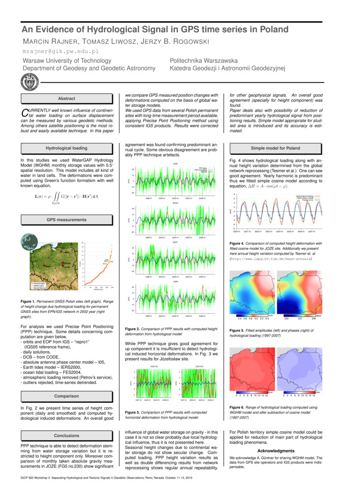
Rajner M., T. Liwosz i J. B. Rogowski. „An Evidence of Hydrological Signal in gps time series in Poland”. igcp 565 Workshop 3: Separating Hydrological and Tectonic Signals in Geodetic Observations. Reno, nv, usa.
- [bib]
@conference{Rajneretalreno10,
}author = {Rajner, Marcin and Liwosz, Tomasz and Rogowski, Jerzy B.}, year = {2010}, title = {An Evidence of Hydrological Signal in gps time series in Poland}, eventtitle = {igcp 565 Workshop 3: Separating Hydrological and Tectonic Signals in Geodetic Observations}, eventdate = {2010-10-11/2010-10-13}, month = {oct}, address = {Reno, nv, usa}, presenter = {Marcin Rajner}, - [.pdf]
- [bib]
-
Rajner M., T. Liwosz i J. B. Rogowski. „An Evidence of Hydrological Signal in gps time series in Poland”. igcp 565 Workshop 3: Separating Hydrological and Tectonic Signals in Geodetic Observations. Reno, nv, usa.
- [bib]
@conference{Rajneretalreno10referat,
}author = {Rajner, Marcin and Liwosz, Tomasz and Rogowski, Jerzy B.}, year = {2010}, title = {An Evidence of Hydrological Signal in gps time series in Poland}, eventtitle = {igcp 565 Workshop 3: Separating Hydrological and Tectonic Signals in Geodetic Observations}, eventdate = {2010-10-11/2010-10-13}, address = {Reno, nv, usa}, presenter = {Marcin Rajner}, month = {oct}, - [.pdf]
- [bib]
-
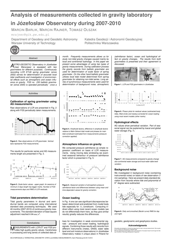
Barlik M., M. Rajner i T. Olszak. „Analysis of measurements collected in gravity laboratory in Józefosław Observatory during 2007-2010”. International Association of Geodesy Symposium on Terrestial Gravimetry: Static and Mobile Measurements (tg-smm2010). Sankt Petersburg, Rosja.
- [bib]
@conference{Barlik10c,
}author = {Barlik, Marcin and Rajner, Marcin and Olszak, Tomasz}, title = {Analysis of measurements collected in gravity laboratory in Józefosław Observatory during 2007-2010}, year = {2010}, eventtitle = {International Association of Geodesy Symposium on Terrestial Gravimetry: Static and Mobile Measurements (tg-smm2010)}, address = {Sankt Petersburg, Rosja}, eventdate = {2010-06-22/2010-06-25}, presenter = {Marcin Rajner}, month = {jun}, - [.pdf]
- [bib]
-
Barlik M., M. Rajner i T. Olszak. „Analysis of measurements collected in gravity laboratory in Józefosław observatory during 2007-2010”. International Association of Geodesy Symposium on Terrestial Gravimetry: Static and Mobile Measurements (tg-smm2010). Sankt Petersburg, Rosja.
- [bib]
@conference{Barlik10c_,
}author = {Barlik, Marcin and Rajner, Marcin and Olszak, Tomasz}, title = {Analysis of measurements collected in gravity laboratory in Józefosław observatory during 2007-2010}, year = {2010}, eventtitle = {International Association of Geodesy Symposium on Terrestial Gravimetry: Static and Mobile Measurements (tg-smm2010)}, address = {Sankt Petersburg, Rosja}, eventdate = {2010-06-22/2010-06-25}, presenter = {Marcin Rajner}, month = {jun}, - [.pdf]
- [bib]
-
Rogowski J. B., T. Liwosz, M. Kruczyk, L. Kujawa, M. Rajner, T. Olszak i W. Kurka. „Obserwatorium w Józefosławiu, stan aktualny i zamierzenia na przyszłość”. Satelitarne metody wyznaczania pozycji we współczesnej geodezji i nawigacji. Olsztyn.
- [bib]
@conference{Rogowski10a,
}author = {Rogowski, Jerzy B. and Liwosz, Tomasz and Kruczyk, Michał and Kujawa, Lech and Rajner, Marcin and Olszak, Tomasz and Kurka, Wiesław}, title = {Obserwatorium w Józefosławiu, stan aktualny i zamierzenia na przyszłość}, year = {2010}, presenter = {Jerzy B. Rogowski}, eventtitle = {Satelitarne metody wyznaczania pozycji we współczesnej geodezji i nawigacji}, address = {Olsztyn}, eventdate = {2010-05-20/2010-05-21}, month = {may},
- [bib]
-
Rajner M. i T. Liwosz. „Badanie wpływu zmian sezonowych stosunków wodnych na wyznaczenie pozycji z obserwacji gps”. Satelitarne metody wyznaczania pozycji we współczesnej geodezji i nawigacji. Olsztyn.
- [bib]
@conference{Rajner10c,
}author = {Rajner, Marcin and Liwosz, Tomasz}, title = {Badanie wpływu zmian sezonowych stosunków wodnych na wyznaczenie pozycji z obserwacji gps}, year = {2010}, eventtitle = {Satelitarne metody wyznaczania pozycji we współczesnej geodezji i nawigacji}, address = {Olsztyn}, eventdate = {2010-05-20/2010-05-21}, month = {may}, presenter = {Marcin Rajner}, - [.pdf]
- [bib]
-
Barlik M., T. Olszak, A. Pachuta, D. Próchniewicz i M. Rajner. „Activities of the gravimetric laboratory at Józefosław observatory”. egu General Assembly, egu General Assembly Conference Abstracts, 12:7138. Wiedeń, Austria.
- [bib]
@conference{Barlik10a,
}author = {Barlik, Marcin and Olszak, Tomasz and Pachuta, Andrzej and Próchniewicz, Dominik and Rajner, Marcin}, title = {Activities of the gravimetric laboratory at Józefosław observatory}, year = {2010}, eventtitle = {egu General Assembly}, address = {Wiedeń, Austria}, eventdate = {2010-05-02/2010-05-07}, booktitle = {egu General Assembly Conference Abstracts}, series = {egu General Assembly Conference Abstracts}, volume = {12}, month = {may}, pages = {7138},
- [bib]
-
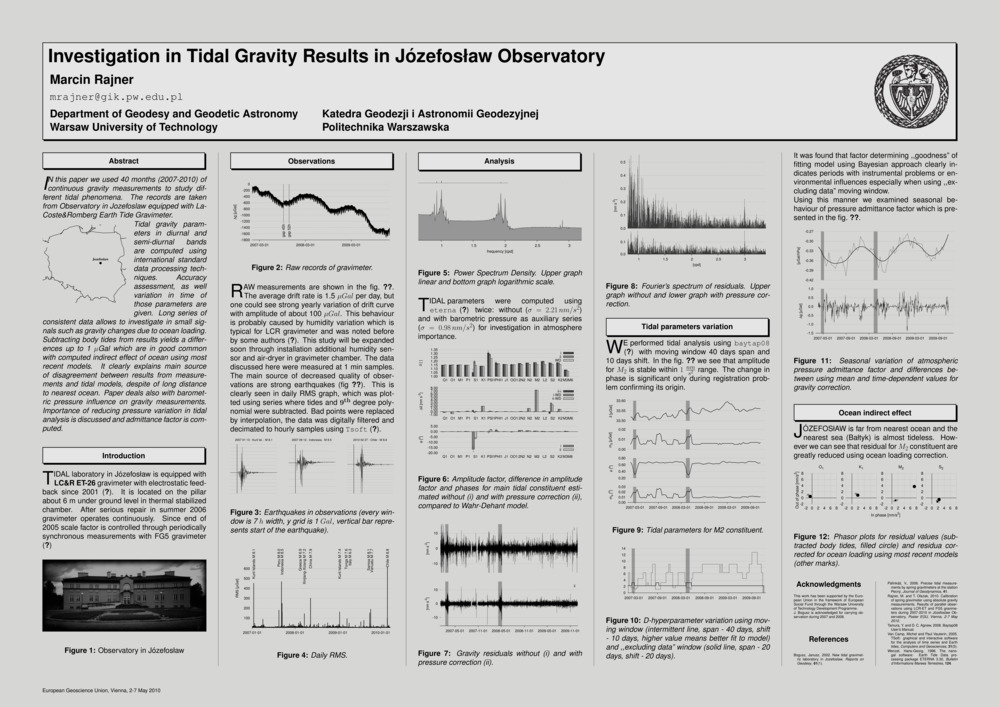
Rajner M. „Investigation in Tidal Gravity Results in Józefosław observatory”. egu General Assembly, egu General Assembly Conference Abstracts, 12:5925. Wiedeń, Austria.
- [bib]
@conference{Rajner10b,
}author = {Rajner, Marcin}, title = {Investigation in Tidal Gravity Results in Józefosław observatory}, year = {2010}, eventtitle = {egu General Assembly}, address = {Wiedeń, Austria}, eventdate = {2010-05-02/2010-05-07}, booktitle = {egu General Assembly Conference Abstracts}, series = {egu General Assembly Conference Abstracts}, volume = {12}, month = {may}, pages = {5925}, - [.pdf]
- [bib]
-
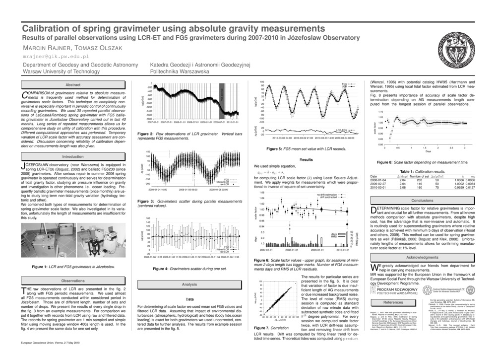
Rajner M. i T. Olszak. „Calibration of spring gravimeter using absolute gravity measurements. Results of parallel observations using lcr-et and fg5 gravimeters during 2007-2010 in Józefosław Observatory”. egu General Assembly, egu General Assembly Conference Abstracts, 12:5919. Wiedeń, Austria.
- [bib]
@conference{Rajner10a,
}author = {Rajner, Marcin and Olszak, Tomasz}, title = {Calibration of spring gravimeter using absolute gravity measurements. Results of parallel observations using lcr-et and fg5 gravimeters during 2007-2010 in Józefosław Observatory}, year = {2010}, eventtitle = {egu General Assembly}, address = {Wiedeń, Austria}, eventdate = {2010-05-02/2010-05-07}, booktitle = {egu General Assembly Conference Abstracts}, series = {egu General Assembly Conference Abstracts}, volume = {12}, month = {may}, pages = {5919}, - [.pdf]
- [bib]
2009
-
Pachuta A., J. Walo, A. Adamek, M. Rajner, M. Woźniak i K. Węzka. „Prace geodezyjne podczas polarnych wypraw na Spitsbergen organizowanych przez Politechnikę Warszawską”. Lwów, Ukraina.
- [bib]
@conference{Pachuta09p,
}author = {Pachuta, Andrzej and Walo, Janusz and Adamek, Artur and Rajner, Marcin and Woźniak, Marek and Węzka, Kinga}, title = {Prace geodezyjne podczas polarnych wypraw na Spitsbergen organizowanych przez Politechnikę Warszawską}, year = {2009}, address = {Lwów, Ukraina}, presenter = {Andrzej Pachuta},
- [bib]
2008
-
Pachuta A., J. Walo, A. Adamek, M. Woźniak, M. Rajner, K. Węzka i D. Próchniewicz. „Geodetic Measurements on Svalbard during Scientific Expeditions Organized by the Warsaw University of Technology (wut)”. fig Working Week. Sztokholm, Szwecja.
- [bib]
@conference{Pachuta08,
}author = {Pachuta, Andrzej and Walo, Janusz and Adamek, Artur and Woźniak, Marek and Rajner, Marcin and Węzka, Kinga and Próchniewicz, Dominik}, title = {Geodetic Measurements on Svalbard during Scientific Expeditions Organized by the Warsaw University of Technology (wut)}, eventtitle = {fig Working Week}, address = {Sztokholm, Szwecja}, eventdate = {2008-06-14/2008-06-19}, month = {jun}, year = {2008}, presenter = {Andrzej Pachuta},
- [bib]
-
Walo J., K. Węzka, Z. Malinowski, M. Rajner, A. Adamek, A. Pachuta i D. Próchniewicz. „Monitoring of thickness and movements of the Hans glacier surface in a period of 2005-2006 by using gps-rtk technology”. International Geodetic Student Meeting. Walencja, Hiszpania.
- [bib]
@conference{Walo08,
}author = {Walo, Janusz and Węzka, Kinga and Malinowski, Zbigniew and Rajner, Marcin and Adamek, Artur and Pachuta, Andrzej and Próchniewicz, Dominik}, title = {Monitoring of thickness and movements of the Hans glacier surface in a period of 2005-2006 by using gps-rtk technology}, eventtitle = {International Geodetic Student Meeting}, address = {Walencja, Hiszpania}, month = {may}, year = {2008},
- [bib]
2007
-
Walo J., A. Adamek, D. Próchniewicz, M. Rajner, K. Węzka i Z. Malinowski. „Analiza pomiarów sieci geodynamicznej w okolicach fiordu Hornsund na Spitsbergenie”. Ogólnopolska Konferencja Kół Naukowych Studentów Geodezji. Kraków.
- [bib]
@conference{Walo07_2,
}author = {Walo, Janusz and Adamek, Artur and Próchniewicz, Dominik and Rajner, Marcin and Węzka, Kinga and Malinowski, Zbigniew}, year = {2007}, title = {Analiza pomiarów sieci geodynamicznej w okolicach fiordu Hornsund na Spitsbergenie}, eventtitle = {Ogólnopolska Konferencja Kół Naukowych Studentów Geodezji}, eventdate = {2007-04-19/2007-04-21}, month = {apr}, address = {Kraków}, venue = {agh}, presenter = {Kinga Węzka}, note = {wyróżnienie w sesji referatowej},
- [bib]
-
Węzka K., A. Pachuta, M. Rajner, D. Próchniewicz, J. Walo i A. Adamek. „Monitoring of thickness and movements of the Hans glacier surface in a period of 2005-2006 by using gps-rtk technology”. egu General Assembly, Geophysical Research Abstracts, 9:11039. Wiedeń, Austria.
- [bib]
@conference{Wezka07,
}author = {Węzka, Kinga and Pachuta, Andrzej and Rajner, Marcin and Próchniewicz, Dominik and Walo, Janusz and Adamek, Artur}, title = {Monitoring of thickness and movements of the Hans glacier surface in a period of 2005-2006 by using gps-rtk technology}, year = {2007}, eventtitle = {egu General Assembly}, address = {Wiedeń, Austria}, booktitle = {Geophysical Research Abstracts}, volume = {9}, pages = {11039}, - [streszczenie]
The aim of the expedition organised in the summer 2006 by the Faculty of Geodesy and Cartography of the Warsaw University of Technology was the determination of thickness and motion of the selected part of the Hans glacier. Based on the surveys data from the last year the lateral profile has been staked out and set up near the 4th ablation pole. gps-rtk surveys were undertaken on the profile in three epochs. The technology has provided the determination of the glacier motion by the most useful and economic method. The paper presents the analysis of the measurements.
- [.pdf]
- [bib]
-
Pachuta A., J. Walo, M. Woźniak, A. Adamek, K. Węzka, D. Próchniewicz i M. Rajner. „Prace geodezyjne realizowane podczas wypraw arktycznych pracowników i studentów Wydziału Geodezji i Kartografii Politechniki Warszawskiej”. Problemy w Geodezji Inżynieryjno-Przemysłowej. Warszawa.
- [bib]
@conference{Pachuta07b,
}author = {Pachuta, Andrzej and Walo, Janusz and Woźniak, Marek and Adamek, Artur and Węzka, Kinga and Próchniewicz, Dominik and Rajner, Marcin}, title = {Prace geodezyjne realizowane podczas wypraw arktycznych pracowników i studentów Wydziału Geodezji i Kartografii Politechniki Warszawskiej}, eventtitle = {Problemy w Geodezji Inżynieryjno-Przemysłowej}, address = {Warszawa}, year = {2007},
- [bib]
2006
-
Walo J., K. Węzka, A. Adamek, M. Rajner, Z. Malinowski i A. Pachuta. „Polish Geodetic Students Expeditions to the Horsund Fjord in Spitsbergen”. Shaping the Change, xxiii fig Congress. Monachium, Niemcy.
- [bib]
@conference{Wezka06a,
}author = {Walo, Janusz and Węzka, Kinga and Adamek, Artur and Rajner, Marcin and Malinowski, Zbigniew and Pachuta, Andrzej}, title = {Polish Geodetic Students Expeditions to the Horsund Fjord in Spitsbergen}, year = {2006}, eventtitle = {Shaping the Change, xxiii fig Congress}, address = {Monachium, Niemcy}, eventdate = {2006-10-08/2006-10-13}, presenter = {Węzka, Kinga}, month = {oct}, - [.pdf]
- [bib]
-
Węzka K., Z. Malinowski, M. Rajner i A. Adamek. „Badanie powierzchniowego ruchu lodowca Hansa na Spitsbergenie, Research of Hans Glacier Surface Speed, Spitsbergen”. Juniorstav. Brno, Czechy.
- [bib]
@conference{Wezka06b,
}author = {Węzka, Kinga and Malinowski, Zbigniew and Rajner, Marcin and Adamek, Artur}, title = {Badanie powierzchniowego ruchu lodowca Hansa na Spitsbergenie, Research of Hans Glacier Surface Speed, Spitsbergen}, eventtitle = {Juniorstav}, address = {Brno, Czechy}, eventdate = {2006-01-24/2006-01-26}, month = {jan}, year = {2006}, presenter = {Marcin Rajner}, - [.pdf]
- [bib]
-
Walo J., A. Pachuta, A. Adamek, K. Węzka, M. Rajner i Z. Malinowski. „Using gps reference station near Polish Polar Station in Spitsbergen for environment monitoring and geodynamic purposes”. egu General Assembly. Wiedeń, Austria.
- [bib]
@conference{Walo06nie07,
}author = {Walo, Janusz and Pachuta, Andrzej and Adamek, Artur and Węzka, Kinga and Rajner, Marcin and Malinowski, Zbigniew}, title = {Using gps reference station near Polish Polar Station in Spitsbergen for environment monitoring and geodynamic purposes}, year = {2006}, eventtitle = {egu General Assembly}, address = {Wiedeń, Austria},
- [bib]
-
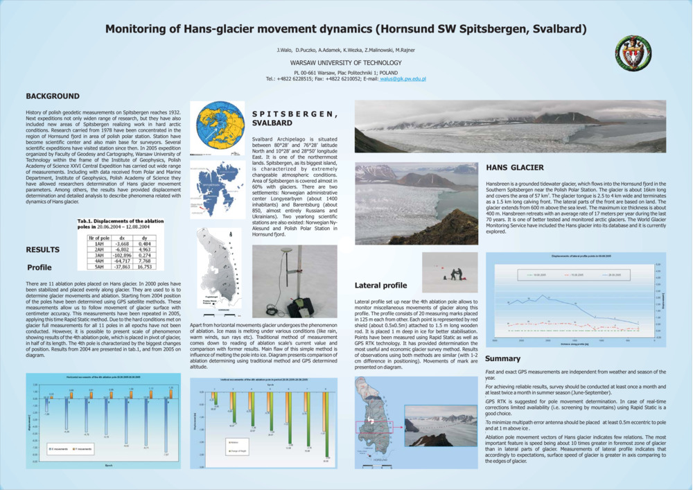
Walo J., D. Puczko, A. Adamek, K. Węzka, M. Rajner i Z. Malinowski. „Monitoring of Hans Glacier movement dynamics (Hornsund sw Spitsbergen, Svalbard)”. egu General Assembly. Wiedeń, Austria.
- [bib]
@conference{Walo06b,
}author = {Walo, Janusz and Puczko, Dariusz and Adamek, Artur and Węzka, Kinga and Rajner, Marcin and Malinowski, Zbigniew}, title = {Monitoring of Hans Glacier movement dynamics (Hornsund sw Spitsbergen, Svalbard)}, eventtitle = {egu General Assembly}, address = {Wiedeń, Austria}, year = {2006}, - [streszczenie]
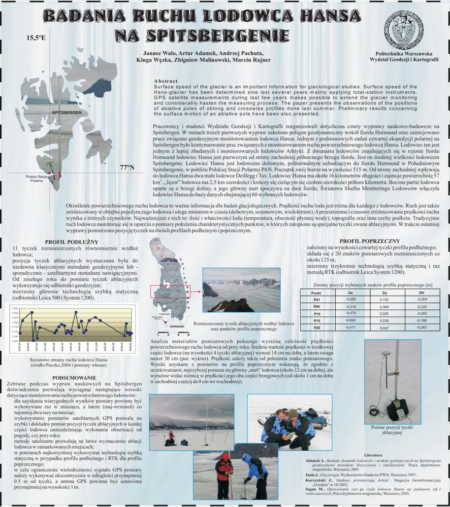
Surface speed of the glacier is an important information for glaciological studies. Surface speed of the Hans-glacier has been determined sine last several years mainly applying total-station instruments. GPS satellite measurements during last few years make possible to extend the glacier monitoring and considerably hasten the measuring process. The paper presents the observations done last summer of the positions of ablative poles oblong and crosswise profiles. The results concerning the surface motion of an ablative pole are presented in the paper.
- [.pdf]
- [bib]
-
Walo J., K. Węzka, Z. Malinowski, M. Rajner i A. Adamek. „Pomiary geodezyjne na Spitsbergenie”. Ogólnopolska Konferencja Kół Naukowych Studentów Geodezji.
- [bib]
@conference{Walo06d,
}author = {Walo, Janusz and Węzka, Kinga and Malinowski, Zbigniew and Rajner, Marcin and Adamek, Artur}, title = {Pomiary geodezyjne na Spitsbergenie}, eventtitle = {Ogólnopolska Konferencja Kół Naukowych Studentów Geodezji}, year = {2006}, venue = {pw}, presenter = {Kinga Węzka},
- [bib]
2005
-
Walo J., A. Adamek, A. Pachuta, K. Węzka, Z. Malinowski i M. Rajner. „Badania ruchu lodowca Hansa na Spitsbergenie”. Geodetické siete a priestorové informácie. Podbanské, Słowacja.
- [bib]
@conference{Walo05b,
}author = {Walo, Janusz and Adamek, Artur and Pachuta, Andrzej and Węzka, Kinga and Malinowski, Zbigniew and Rajner, Marcin}, title = {Badania ruchu lodowca Hansa na Spitsbergenie}, eventtitle = {Geodetické siete a priestorové informácie}, eventdate = {2005-10-24/2005-10-26}, address = {Podbanské, Słowacja}, month = {oct}, year = {2005}, - [streszczenie]
Określenie powierzchniowej prędkości lodowca to ważna informacja dla badań glacjologicznych. Powierzchniowy ruch lodowca Hansa wyznaczany jest od kilku lat głównie za pomocą tachimetru elektronicznego. Wykorzystanie w ostatnich dwóch latach w obserwacji satelitarnych GPS pozwoliło rozszerzyć zasięg monitorowania lodowca i znacznie przyspieszyć prace pomiarowe. W referacie omówione zostały pomiary pozycji tyczek profili podłu nego i poprzecznego wykonane latem tego roku. Prezentowane są te wstępne wyniki dotyczące ruchu powierzchniowego dla wybranej tyczki ablacyjnej.
Surface speed of the glacier is an important information for glaciological studies. Surface speed of the Hans-glacier has been determined sine last several years mainly applying total-station instruments. GPS satellite measurements during last few years makes possible to extend the glacier monitoring and considerably hasten the measuring process. The paper presents the observations of the positions of ablative poles of oblong and crosswise profiles done last summer. Preliminary results concerning the surface motion of an ablative pole have been also presented. - [.pdf]
- [bib]